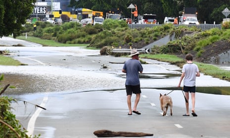
A man has been found dead near his vehicle in Queensland flood waters as storms bring heavy rain to eastern Australia.
Police found the 71-year-old man at 5.20am on Thursday, after being called to the Logan suburb of Greenbank to conduct a welfare check.
Two weather systems are colliding to bring thunderstorms, heavy rain and flash flooding across eastern Australia. Rainfall totals of up to 200mm are expected in Queensland and New South Wales.
The troughs were passing over each other causing wild weather in Queensland’s south and northern NSW, the Bureau of Meteorology said on Thursday morning.
Stormy skies are headed for northern NSW in an event colloquially known as a “black nor’easter”, according to BoM senior meteorologist Dean Narramore.
“When you have these big coastal troughs, the sunshine would disappear,” he said.
“You get these really dark clouds moving along the NSW coast, really strong onshore winds as well, and it will bring widespread heavy and flooding rain.”
Floods have already hit Queensland’s south and flood watch alerts are in place for much of Australia’s east coast.
Greenbank was one of multiple Queensland sites hit with more than 100mm of rainfall in only one hour last night, with floods forcing almost 30 road closures across the state.
Queensland’s SES attended to 15 flood incidents overnight, assisting with fallen trees and setting up tarps in the Gold Coast, Ipswich, and Logan areas.
The Lower Brisbane River catchment was at risk of major flooding on Thursday morning, after widespread totals of 50-100 mm overnight.
Northern NSW has seen flash flooding and rainfalls of over 80mm in just three hours on Thursday morning as the clashing weather systems move south. Lismore could face flooding from Thursday evening as the Wilsons River rises.
Showers will move south through NSW’s Hunter, North Coast and Sydney regions by Thursday afternoon, according to Narramore.
“That rain will just continue to expand and intensify tonight and tomorrow, and then spread down much of the NSW coast and inland areas as well over tomorrow and Saturday,” he said.
The bureau has warned that coastal NSW will be hit with severe rainfall and damaging winds, with intense downpours possibly lasting uninterrupted into the weekend.
Sydney’s dam is also likely to overflow on Friday, with up to 140mm of rain forecast for Warragamba, while major flooding is likely for NSW’s Hawkesbury-Nepean River.
“Sydney will have a very wet day tomorrow – even if there’s not major riverine flooding, you could definitely see flash flooding on the streets,” Narramore said.
after newsletter promotion
The Darling Downs, granite belt and Maranoa in Queensland’s south-west were forecast to get thunderstorm activity on Thursday with widespread rainfall totals between 20mm and 50mm.
Isolated falls that increase the risk of flooding could be up to 100mm in towns from Charleville to Goondiwindi and over to the Gold Coast.
A flood watch was issued for dozens of catchments across the state’s south-west including the Paroo River, Wallam and Mungallala creeks and Moonie River.
The bureau said flood waters could rise on Thursday night.
For residents near the Moonie and Condamine rivers, it marks just a few months since river levels rose and flooded homes in a January emergency.
The weather system will move south into northern NSW, developing into a low pressure system and bringing widespread rain of 30mm to 50mm and up to 100mm in some areas.
NSW State Emergency Services are preparing for the worst, and residents were urged to get ready for the storms.
“Flood and storms teams are on standby to respond should they be required, but we’re pleading with the community to be prepared, stay informed and not drive through flood waters,” assistant commissioner Sean Kearns said.
The wild weather is expected to ease up over the weekend as the system moves south and off the coast.
“Friday and Friday night will be the worst of it – it’ll be continuing Saturday morning, but then it’s going to start moving further south into eastern parts of Victoria and then out into the ocean on Saturday and Saturday night,” Narramore said.
