
Appalachian Voices
Appalachian Voices is an environmental nonprofit organization committed to protecting the land, air, water and communities of the central and southern Appalachian region. Focused on reducing coal's impact and advancing a vision of a cleaner energy future, we use Google Earth and Google Maps to further our cause.
Mountaintop removal mining uses explosives to mine coal seams that would otherwise be difficult to access. The practice is irreversibly detrimental to the surrounding environment, polluting nearby drinking water sources and permanently destroying the mountains themselves and is strongly linked to cancer and other diseases in nearby communities.
Appalachian Voices has educated millions of people, from policy-makers and legislators to ordinary citizens, about this destructive process. How? By transporting them to more than 500 destroyed mountains in Appalachia using Google Earth and Google Maps.
How they did it
Mountaintop removal coal mining is changing the American landscape on a scale that is hard to comprehend unless you see it from the air. Anyone who has ever flown in a small aircraft over southern West Virginia or eastern Kentucky will never forget the experience of seeing the massive scale of destruction — mountain after mountain blown up and dumped into valleys as far as the eye can see. Appalachian people working to save their communities long dreamed of a way to fly reporters, decision-makers, and thousands of other Americans over the Appalachian coalfields to see this destruction first hand — and then take them to visit their communities to hear the stories of people who endure the consequences of what some have called "cheap energy."
With Google Earth, Appalachian Voices created an approximation of that tour, accessible to anyone with a computer and a high-speed internet connection, extending our reach by millions of people. Visitors to the Google Earth layer can take a high-resolution tour of a large mine site, watch first-hand video stories about the mountains and their communities, and access before-and-after overlays for hundreds of mountains destroyed by mountaintop removal. They can also bring the experience closer to home by overlaying the 15-square-mile Hobet mining complex in West Virginia on top of 36 different U.S. cities to understand the sheer scale of the devastation.
 “
“The Hobet mountain mine in 2011 (left) and 1984 (right), before mountaintop removal operations began.
”
We also wanted to create a tool to allow Americans to explore their personal connection to mountaintop removal in Appalachia. By entering their zip code in our simple and intuitive "My Connection" interactive map, visitors can see their direct or indirect connection to mountaintop removal through their local electricity provider. The website uses both graphics and text to explain a user's mountaintop removal connection, and provides a narrative description of the communities impacted by the mine. This map was built using Google Maps Platform, KML, and a MySQL database.
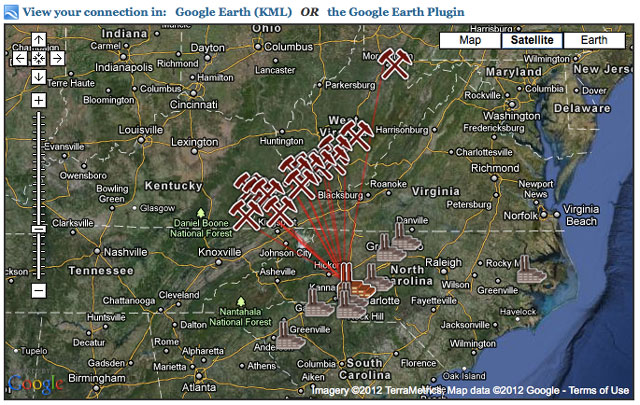 “
“Appalachian Voices's "My Connection" interactive map
” “The newest tool on iLoveMountains.org, called "The Human Cost of Coal", is an accumulation of data from verified government sources and peer-reviewed scientific studies plotted on a Google Map. Built by Appalachian Voices and our allies in The Alliance for Appalachia, it shows the correlation between mountaintop removal coal mining and increased health problems, lowered life expectancy and high poverty rates in Central Appalachia.
”It is important to realize that birth defects for babies born in [areas impacted by] mountaintop removal are over twice as high than if the mother smokes during pregnancy, and over 10 times as high for circulatory and respiratory defects.
”Vernon Haltom from Coal River Mountain Watch.
"The Human Cost of Coal" layer pulls from national data including poverty rates from U.S. Census, the Gallup-Healthways Well-Being Index and life expectancy and population numbers from the Institute for Health Metrics and Evaluation. The site also includes summaries for more than twenty peer-reviewed scientific studies that provide evidence that human health problems such as heart, respiratory and kidney diseases, cancer, low birth weight and serious birth defects are significantly higher in communities near mountaintop removal mine sites.
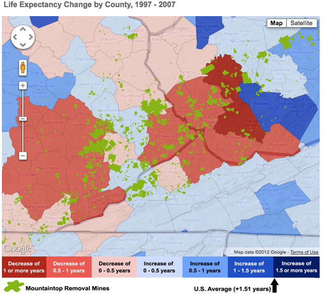 “
“Life expectancy change by county in areas where mountaintop removal mines are located, visualized in the interactive maps of "The Human Cost of Coal".
”
There is a common saying in Appalachia: what we do to the land, we do to the people. "The Human Cost of Coal" project confirms the truth of those words.
Another recent project by Appalachian Voices is Appalachian Water Watch , a program that pairs hands-on citizen water monitoring with the high-tech mapping capabilities of Google Maps to track the negative impacts of mining on water quality. Appalachian citizens in coal-impacted regions are first trained and equipped with the knowledge, instruments and professional support to monitor their local streams, rivers and ponds for pollution generated by mountaintop removal coal mining. The citizens then input data such as GPS coordinates, conductivity and pH levels, and weather at the time of testing into Google Maps. This allows citizens to monitor water quality and share data across communities to identify areas of concern to better protect the people and waterways of Central Appalachia. Appalachian Voices, our partners and impacted citizens have already brought lawsuits against offending coal companies for Clean Water Act violations in Kentucky and are currently reviewing potential offenses in other coal mining states.
Google Earth revolutionized the way we tell people about what's going on in the Appalachian Mountains. Without it, hundreds of thousands of people would not know about the destruction of my homeland.
”Benji Burrell, technologist, Appalachian Voices
Impact
Appalachian Voices’ use of Google Earth and Google Maps has received major national media coverage and recognition for innovation, and has brought the mountaintop removal issue to a massive new audience. The iLoveMountains Google Earth layer has been used in presentations to hundreds of live audiences, ranging from small church groups and rotary clubs to large conferences and keynote presentations. YouTube videos incorporating the layer have been viewed by more than 800,000 people to date. Celebrities and decision makers, including Leonardo DiCaprio, Robert F. Kennedy, Jr., Woody Harrelson, Sheryl Crow, Kathy Mattea, Congressman Frank Pallone and Senator Lamar Alexander have helped spread the word about the iLoveMountains tools.
In the ten days following the release of the Appalachian Mountaintop Removal layer in Google Earth, more than 13,000 people — hailing from every state in the U.S. as well as over 30 countries — signed an online petition to stop the dumping of mountaintop removal mining waste into waterways. Not only has this endeavor brought significant regional and national media attention to the issue, but the traffic on iLoveMountains.org , and the number of people joining the movement to stop mountaintop removal, has been boosted to a new level.
Appalachian Voices and our allies in The Alliance for Appalachia have accomplished several victories through our work with Google Earth and Google Maps. Over the past five years and armed with images and media generated by our Google tools, we have spoken with hundreds of members of Congress and their staffs about mountaintop removal coal mining in Appalachia. In that time, over 200 bi-partisan congressional representatives in both the House and Senate have taken the key step of cosponsoring legislation to help end mountaintop removal.
The Appalachian Mountains represent a vibrant and indelible culture, stunning biodiversity and enormous economic potential. With Google Earth and Google Maps, Appalachian Voices has drawn together coal-mining communities, shared their stories and made a compelling case for protecting vital resources.