US9008960B2 - Computation of travel routes, durations, and plans over multiple contexts - Google Patents

Computation of travel routes, durations, and plans over multiple contexts Download PDF

Info

Publication number
US9008960B2
US9008960B2 US13/922,002 US201313922002A US9008960B2 US 9008960 B2 US9008960 B2 US 9008960B2 US 201313922002 A US201313922002 A US 201313922002A US 9008960 B2 US9008960 B2 US 9008960B2
Authority
US
United States
Prior art keywords
journey
time
user
analysis component
identified
Prior art date
Legal status (The legal status is an assumption and is not a legal conclusion. Google has not performed a legal analysis and makes no representation as to the accuracy of the status listed.)
Active, expires
Application number
US13/922,002
Other versions
US20130345966A1 (en
Inventor
Eric J. Horvitz
Current Assignee (The listed assignees may be inaccurate. Google has not performed a legal analysis and makes no representation or warranty as to the accuracy of the list.)
Microsoft Technology Licensing LLC
Original Assignee
Microsoft Technology Licensing LLC
Priority date (The priority date is an assumption and is not a legal conclusion. Google has not performed a legal analysis and makes no representation as to the accuracy of the date listed.)
Filing date
Publication date
Application filed by Microsoft Technology Licensing LLC filed Critical Microsoft Technology Licensing LLC
Priority to US13/922,002 priority Critical patent/US9008960B2/en
Publication of US20130345966A1 publication Critical patent/US20130345966A1/en
Assigned to MICROSOFT TECHNOLOGY LICENSING, LLC reassignment MICROSOFT TECHNOLOGY LICENSING, LLC ASSIGNMENT OF ASSIGNORS INTEREST (SEE DOCUMENT FOR DETAILS). Assignors: MICROSOFT CORPORATION
Assigned to MICROSOFT CORPORATION reassignment MICROSOFT CORPORATION ASSIGNMENT OF ASSIGNORS INTEREST (SEE DOCUMENT FOR DETAILS). Assignors: HORVITZ, ERIC J.
Priority to US14/645,197 priority patent/US20150185037A1/en
Application granted granted Critical
Publication of US9008960B2 publication Critical patent/US9008960B2/en
Active legal-status Critical Current
Adjusted expiration legal-status Critical

Links

Images

Classifications

    • GPHYSICS
    • G01MEASURING; TESTING
    • G01CMEASURING DISTANCES, LEVELS OR BEARINGS; SURVEYING; NAVIGATION; GYROSCOPIC INSTRUMENTS; PHOTOGRAMMETRY OR VIDEOGRAMMETRY
    • G01C21/00Navigation; Navigational instruments not provided for in groups G01C1/00 - G01C19/00
    • G01C21/26Navigation; Navigational instruments not provided for in groups G01C1/00 - G01C19/00 specially adapted for navigation in a road network
    • G01C21/34Route searching; Route guidance
    • G01C21/36Input/output arrangements for on-board computers
    • G01C21/3605Destination input or retrieval
    • G01C21/3617Destination input or retrieval using user history, behaviour, conditions or preferences, e.g. predicted or inferred from previous use or current movement
    • GPHYSICS
    • G01MEASURING; TESTING
    • G01CMEASURING DISTANCES, LEVELS OR BEARINGS; SURVEYING; NAVIGATION; GYROSCOPIC INSTRUMENTS; PHOTOGRAMMETRY OR VIDEOGRAMMETRY
    • G01C21/00Navigation; Navigational instruments not provided for in groups G01C1/00 - G01C19/00
    • G01C21/26Navigation; Navigational instruments not provided for in groups G01C1/00 - G01C19/00 specially adapted for navigation in a road network
    • G01C21/34Route searching; Route guidance
    • G01C21/3453Special cost functions, i.e. other than distance or default speed limit of road segments
    • G01C21/3492Special cost functions, i.e. other than distance or default speed limit of road segments employing speed data or traffic data, e.g. real-time or historical
    • GPHYSICS
    • G01MEASURING; TESTING
    • G01CMEASURING DISTANCES, LEVELS OR BEARINGS; SURVEYING; NAVIGATION; GYROSCOPIC INSTRUMENTS; PHOTOGRAMMETRY OR VIDEOGRAMMETRY
    • G01C21/00Navigation; Navigational instruments not provided for in groups G01C1/00 - G01C19/00
    • G01C21/26Navigation; Navigational instruments not provided for in groups G01C1/00 - G01C19/00 specially adapted for navigation in a road network
    • G01C21/34Route searching; Route guidance

Definitions

  • Computer-driven route planning applications are utilized every day to aid users in locating points of interest, such as particular buildings, addresses, and the like. Additionally, in several existent commercial applications users can vary a zoom level, thereby enabling variation of context and detail as a zoom level of a map is altered. For example, as a user zooms in on a particular location, details such as names of local roads, identification and location of police and fire stations, identification and location of public services, such as libraries, museums, and the like can be provided to the user. When zooming out, the user can glean information from the map such as location of the point of interest within a city, state, and/or country, proximity of the point of interest to major freeways, proximity of the point of interest to a specific city, and the like.
  • satellite images can be utilized to provide users with additional detail regarding a particular geographic location or region. For example, a prospective purchaser of a house can obtain an overhead satellite image of the house, thereby enabling the prospective purchaser to view lines of occupation, proximity of the house to other adjacent houses, and other information that may be pertinent to the user.
  • mapping applications often include route planning applications that can be utilized to provide users with directions between different locations.
  • a user can provide a route planning application with a beginning point of travel and an end point of travel (e.g., beginning and ending addresses).
  • the route planning application can include or utilize representations of roads and intersections and one or more algorithms to output a suggested route of travel. These algorithms can output routes depending upon user-selected parameters.
  • a commercial route planning application can include a check-box that enables a user to specify that she wishes to avoid highways.
  • a user can inform the route planning application that she wishes to travel on a shortest route or a route that takes a least amount of time (as determined by underlying algorithms).
  • Route planning applications are also no longer confined to desktop computers. Rather, several automobiles are now equipped with standard mapping functionality, wherein the automobiles include graphical displays on a console to provide mapping data and directions to a user. Oftentimes, a compact disk or other storage medium that includes data to enable utilization of route-planning functionality must be purchased and loaded prior to use of the route planning application. As road conditions change, such as speed limits, number of lanes, etc., updates can be provided. Automobiles with GPS functionality (or other location identifying functionality) can additionally include real-time directions, wherein directions are provided to users of the automobile while they travel.
  • route planners are fairly reliable in connection with details such as posted speed limits, location of one-way streets, and related information.
  • conventional applications that include route-planning functionality make assumptions regarding state of roads. With more specificity, today's route planning applications are built around assumptions of constancy and universality, such that optimal routes provided by the applications are independent of time of day, day of week, and detailed user preferences. In actuality, however, these assumptions do not hold. For example, in many instances, a best route between two points during rush hour in a metropolitan area is not an optimal route at midnight between the same two points. Conventional route planning applications, however, do not take such context into account when providing routes for users. Conventional route planning applications also have an ability to estimate an amount of time that traveling a route will require.
  • This determination can be based at least in part upon data relating to distances of road segments and posted speed limits associated therewith. Again, however, the route planning applications are based upon the assumption of constancy, meaning that estimated travel time does not change even if time of travel or other context alters.
  • the claimed subject matter relates to a route planning application that can determine estimated travel times given varying contexts.
  • a route planning application that can determine estimated travel times given varying contexts.
  • the systems and methods described herein facilitate estimating travel time between a beginning point and a destination point over varying contexts.
  • an individual can request directions between a beginning point and an end point, and estimated travel times between the two points can be generated for multiple times that travel can be begun. It is understood, however, that estimated travel times can be generated for different weather conditions, different days of the week, etc.
  • a traffic system representation can be accessed, wherein the representation alters as context alters.
  • the traffic system representation can be or include a weighted graph, where nodes represent intersections and edges represent road segments therebetween. The nodes and edges can be weighted, where the weights correspond to average travel speeds associated with intersections and road segments that are represented by the nodes and edges. The weights can then vary as context varies, thus more accurately representing traffic flow within a traffic system. For instance, commuters in a metropolitan area are fully aware that it takes more travel time to travel certain road segments during rush hour when compared to traveling the same road segments at midnight on a weekend.
  • the traffic system representation can be analyzed with respect to various contexts, and estimated travel times between a beginning point and a destination point can be output based at least in part upon the analysis.
  • flows at road segments can be represented by probability distributions over flows and these probability distributions can be a function of contextual observations such as time of day, day of week, calendar information, flows seen at earlier times, and flows in other parts of the traffic system.
  • Probabilistic forecasting models can be trained, wherein the trained forecasting modes one of multiple forecasting methods that take current flows across a traffic system and compute forecasts about future flows on the traffic system.
  • predictions for future flows can be targeted at different times in the future. Beyond the flows, the times until particular states are reached can be predicted, such as the time until a flow becomes significantly slowed or until a jammed region of the traffic system will likely open up to flow at some level of motion.
  • One of several discriminative versus generative statistical methods can be employed for prediction and forecasting over time.
  • These methods include statistical classifiers such as support vector machines, the use of Bayesian structure search within the realm of Bayesian machine learning, the learning and usage of dynamic Bayesian networks and related Hidden Markov Models, Continuous Time Bayesian networks, and families of time-series methods such as those employing Bayesian models, and models known as ARMA and ARIMA forecasting models.
  • estimated travel time can be updated in real time as a user travels over a route.
  • statistical methods can consider as inputs for both training and real-time reasoning real-time inferences, the observations reported by sensors, in addition to contextual information mentioned earlier.
  • a portable device can include multiple sensors which enable location, velocity, acceleration, and/or the like to be determined in real-time.
  • a traffic system representation can be analyzed in light of the real-time data, and an estimated amount of travel time remaining can be provided to the user.
  • travel times can be computed for a trip ahead of time, in a manner that takes into consideration estimates of the time that it will take to get to each segment of a trip.
  • the estimated time required to progress through each segment of a route is computed based on a consideration of the flows at each portion of the route at the time when the driver is expected to arrive at those downstream routes, considering the time of day and day of week and traffic flows throughout a system at the starting time and, optionally, at later times during a trip.
  • the probabilistic forecasting methods can be used to provide such flows at later times for the computation of the overall travel time associated with a route starting at some particular time.
  • “optimal” routes can be provided between the same two points given varying context, thereby providing the user with directions that minimize travel time (while considering driving preferences of the user) for various departure times.
  • the user can provide a beginning point and a destination point and request directions between such points.
  • the systems/methods described herein can, for instance, determine directions between the two points that will result in minimized driving time for various departure times. Therefore, a first set of directions can correspond to a first departure time, a second set of directions can correspond to a second departure time, etc.
  • FIG. 1 is a high-level block diagram of a system that facilitates determining estimated travel times between two points given multiple contexts.
  • FIG. 2 is a block diagram of a system that facilitates determining estimated travel times for a particular route given multiple contexts.
  • FIG. 3 is a block diagram of a system that determines estimated travel times between two points for multiple contexts based at least in part upon detailed driving preferences of a driver.
  • FIG. 4 is a block diagram of a system that determines a sequence with respect to traveling to multiple locations and determines estimated time of travel associated with the sequence.
  • FIG. 5 is a block diagram of a system that facilitates updating a traffic system representation with data collected from one or more sensors.
  • FIG. 6 is a block diagram of a system that facilitates updating remaining travel time between two points based upon sensed parameters associated with the user.
  • FIG. 7 is a block diagram of a system for building/refining a traffic system representation whose contents alter as context changes.
  • FIG. 8 is a representative flow diagram of a methodology for outputting estimated travel times between two points given different departure times.
  • FIG. 9 is a representative flow diagram of a methodology for determining when to begin a journey to minimize estimated travel time.
  • FIG. 10 is a representative flow diagram of a methodology for outputting different directions between two points for different departure times.
  • FIGS. 11 and 12 are screenshots illustrating collection of data from automobiles in a traffic system.
  • FIG. 13 is an example cost-of-time assessment palette.
  • FIG. 14 is an example Bayesian model that can be utilized to determine costs associated with a user's time.
  • FIG. 15 is an example graph that illustrates travel start times and expected travel times with respect to multiple routes.
  • FIG. 16 is a schematic block diagram illustrating a suitable operating environment.
  • FIG. 17 is a schematic block diagram of a sample-computing environment.
  • a component may be, but is not limited to being, a process running on a processor, a processor, an object, an executable, a thread of execution, a program, and a computer.
  • an application running on a server and the server can be a component.
  • One or more components may reside within a process and/or thread of execution and a component may be localized on one computer and/or distributed between two or more computers.
  • the word “exemplary” is used herein to mean serving as an example, instance, or illustration. Any aspect or design described herein as “exemplary” is not necessarily to be construed as preferred or advantageous over other aspects or designs.
  • aspects of the claimed subject matter may be implemented as a method, apparatus, or article of manufacture using standard programming and/or engineering techniques to produce software, firmware, hardware, or any combination thereof to control a computer to implement various aspects of the subject invention.
  • article of manufacture as used herein is intended to encompass a computer program accessible from any computer-readable device, carrier, or media.
  • computer readable media can include but are not limited to magnetic storage devices (e.g., hard disk, floppy disk, magnetic strips, . . . ), optical disks (e.g., compact disk (CD), digital versatile disk (DVD), . . . ), smart cards, and flash memory devices (e.g., card, stick, key drive, . . . ).
  • a carrier wave can be employed to carry computer-readable electronic data such as those used in transmitting and receiving electronic mail or in accessing a network such as the Internet or a local area network (LAN).
  • LAN local area network
  • the systems/methods are generally described herein with respect to users traveling in a traffic system or desirably traveling in a traffic system (e.g., in automobiles). It is to be understood and appreciated, however, that concepts underlying the following description of the figures can be applied to other areas where timing parameters are important, such as bus lines, airport security, walking on campus between classes, cooking (e.g., multi-tasking by trying to make several dishes using a single oven/stove), and other similar areas. Therefore, the following description is not intended to be limited to the field of traffic and/or directions.
  • the system 100 can reside within a server, be distributed across several servers, and/or reside within a client.
  • the system 100 includes a receiver component 102 that receives a request for directions from a user.
  • the request can be provided through utilization of a web browser and templates associated therewith, through a microphone, keypad, or any other suitable input device.
  • the request for directions can include at least two points; a beginning point and a destination point of a journey.
  • the points can correspond to addresses, cities, monuments, regions, landmarks, airports, or any other suitable point.
  • the receiver component 102 is communicatively coupled to an analysis component 104 that is employed to determine timing parameters associated with the request for directions.
  • the analysis component 104 can determine timing parameters associated with the request for directions that are based at least in part upon when the journey will be undertaken.
  • a user can request directions from a beginning point and an ending point, and the analysis component 104 can output timing parameters such as “The journey will take approximately thirty minutes of driving time if the journey begins in five minutes. The journey will take approximately forty five minutes if the journey begins in one hour. The journey will take approximately twenty minutes if the journey begins in five hours.”
  • the analysis component 104 enables a user to minimize drive time by providing different expected travel times given different times with respect to starting the journey. For instance, the analysis component 104 can inform a user when the journey would be expected to take a least amount of time.
  • the analysis component 104 can access a traffic system representation 106 , which can be a context-sensitive representation.
  • the traffic system representation 106 can alter as context changes.
  • the traffic system representation can be and/or include a weighted graph, where nodes of the graph represent intersections, edges represent road segments between the intersections, and weights associated therewith represent average travel speeds for the road segments/intersections.
  • the weights can alter as context alters. For instance, a first weight can be provided for a road segment at a first time of day and a second weight can be provided to the same road segment at a second time of day.
  • the traffic system representation 106 can represent how traffic flows alter given different times of day (e.g., rush hour versus non-rush hour), days of week (e.g., weekday versus weekend), weather conditions (e.g., raining versus sunny), and other suitable contextual data. Still further, the representation 106 can include representations of traffic flows at certain road segments, wherein such flows can be probability distributions over flows and these probability distributions can be a function of contextual observations such as time of day, day of week, calendar information, flows seen at earlier times, flows in other parts of the traffic system, etc.
  • the analysis component 104 can provide different contexts to the traffic system representation 106 , thereby altering weights of nodes and edges therein.
  • the analysis component 104 can then locate a route between the two provided points with a lowest total weight, and can determine an expected time based at least in part upon the total weight. Pursuant to an example, this can be done for increments of time. For instance, the analysis component 104 can provide expected times for the journey for each thirty minute time increment.
  • the analysis component 104 can then cause the timing parameters to be displayed to the user in any suitable order (e.g., from departure times that are expected to require a least amount of time to departure times that are expected to require the most amount of time).
  • the analysis component 104 can also take into account preferences about time for leaving, travel time, and arrival time in relationship to target arrival times, e.g., per events starting, and suggest a departure time and ideal route that maximizes a user's expected utility, including the user's risk preference (risk seeking or risk aversion).
  • the analysis component 104 can output time ranges with respect to an expected time for a journey given different times that the journey will be undertaken. Additionally, the analysis component 104 can output probabilities with respect to travel times. Pursuant to one example, the analysis component 104 can output that, if the user begins the journey in an hour, there is an eighty percent probability that the journey will take between twenty five and thirty five minutes. These probabilities can be based upon historic data as well as current state of a traffic system (e.g., as determined from one or more sensors, traffic reports on web pages or radio stations, . . . ). Further, the analysis component 104 can output a mean time or any other suitable timing information associated with the requested directions.
  • the concepts underlying the system 100 can be applied to various applications.
  • the traffic system representation 106 can be manipulated to represent bus lines, drive through lines, walking areas, time associated with cooking meals, etc.
  • flows e.g., a manner in which traffic is moving or expecting to move
  • flows can be represented by probability distributions over flows and these probability distributions can be a function of contextual observations such as time of day, day of week, calendar information, flows seen at earlier times, and/or flows in other parts of the traffic system.
  • Probabilistic forecasting models can be trained, wherein the models employ one of multiple forecasting methods that take current flows across a traffic system and compute forecasts about future flows on the traffic system, where predictions for future flows can be targeted at different times in the future.
  • the times until particular states are reached can be predicted by the analysis component 104 , such as the time until a flow becomes significantly slowed or until a jammed region of the traffic system will likely open up to flow at some level of motion.
  • One of several discriminative or generative statistical methods can be employed for prediction and forecasting over time. These methods include statistical classifiers such as support vector machines, the use of Bayesian structure search within the realm of Bayesian machine learning, the learning and usage of dynamic Bayesian networks and related Hidden Markov Models, Continuous Time Bayesian Networks (CTBNs), and families of time-series methods such as those employing temporal Bayesian models, and models known as ARMA and ARIMA forecasting models.
  • the analysis component 104 can utilize probabilistic models, including dynamic Bayes networks, continuous time Bayes networks, Hidden Markov models, and various time-series forecasting models to take histories and current states of traffic flows and project them into the future, considering those flows as well as potential contexts such as time of day, day of week, weather, etc.
  • probabilistic models including dynamic Bayes networks, continuous time Bayes networks, Hidden Markov models, and various time-series forecasting models to take histories and current states of traffic flows and project them into the future, considering those flows as well as potential contexts such as time of day, day of week, weather, etc.
  • Such models can be used in connection with computing travel times for a trip ahead of time in a manner that takes into consideration estimates or predictions of the time it will take to get to each segment of a trip.
  • the estimate/predicted time required to progress through each segment of a route (as determined by the analysis component 104 ) can be computed based upon a consideration of flows at each portion of the route at a time when the driver is expected to arrive at those downstream routes, considering the time of day and day of week and traffic flows (predicted or sensed) at a starting time and, optionally, at later times during a trip.
  • Probabilistic forecasting methods employed by the analysis component 104 can be used to provide such flows at later times for computation of an overall travel time associated with a route starting at some particular time.
  • the analysis component 104 can reason about until major transitions in traffic flows, e.g. from a time that a road segment is jammed until the jam melts away into a free-flowing traffic flow). For instance, the analysis component 104 can predict expected travel times for routes at different starting times by considering the likelihood that each jammed segment will remain jammed or when it will open when it is reached as a driver as they progress over a route (and vice versa). Thus, the probability that each portion of a road segment will be jammed as a driver is expected to reach such segment can be determined, and such probability can be propagated forward for determining probabilities associated with states of a next road segment in a route.
  • the analysis component 104 can compute mean times required for a route starting at a given time by considering cascades of probabilities and searching through all possibilities, considering the probabilities of each state and summing over all situations to compute an expected travel time. This computation can be completed for different feasible routes and different feasible starting times, and computation can be searched over to find an optimal starting time and route (given a context and/or observed real-time or recent situation).
  • the analysis component 104 can consider various contextual events in undertaking the aforementioned computation, including occurrence of major events (e.g., sporting events, cultural events), weather, sensed and/or inferred traffic flows, accidents, traffic reports in natural language, closures, historical information, etc.
  • the cascading search strategy can be utilized to compute actual driving times in different contexts and use of such as part of a search to identify best routes and/or best starting times and routes.
  • the analysis component 104 can reason about an optimal time to initiate travel between two or more points based on background statistics (e.g., historical data) and/or on real-time observations within a traffic system. For example, given certain statements in the request for directions, such as travel duration and arrival times, different starting times and routes can be generated with a consideration of such preferences. For example, a driver may state a need to arrive with a particular probability by a certain amount of time (or a cost of delayed arrival where cost starts to accrue at a particular time) and also state that driving time is desirably minimized.
  • a user can provide a utility model that provides a cost of total driving time and of being late (or early) to an appointment and have an optimization system compute a best time to leave and a best route to take to minimize the expected cost to the user under uncertainty. For instance, a user may assert that they do not wish to leave on a route at times when leaving would allow them to arrive earlier on average because of likely clearing of traffic jams.
  • the system 100 can be utilized in various manners.
  • the system 100 can be an alerting system that informs a driver as to when to leave while taking a trip.
  • the system 100 can be employed to generate recommendations that inform to perform a task rather than to start or continue a trip so as to make ideal use of the user's time (e.g., when there is a list of pending goals and waiting and/or getting other things done would be a better use of time than sitting in traffic).
  • advertisements can be sold and rendered to a user given timing information associated with a route (e.g., when it is best that a user starts a route later and can undertake a task that takes about the right time for traffic to become free-flowing).
  • system 100 can be utilized to generate recommendations for a time to start travel given a preference.
  • system 100 can be utilized in connection with an alarm clock that has access to a user's appointments and can wake the person up later or earlier depending upon predicted traffic flows (based upon the analysis as described above).
  • the system 100 described herein can search for ideal routes between points as well as starting times between routes, and based upon context the analysis component 104 can identify candidates for both a route to travel over and a starting time that maximizes a user's expected utility and/or minimizes overall cost to a user.
  • a Dykstra search algorithm, an A* search algorithm, and/or a variant thereof can be utilized to perform route planning while considering contextual events (e.g., time of day, day of week, month, weather, . . . and a start time or a range of start times where the user is expected to reach certain portions of a possible routes.
  • the search can be performed for multiple start times, and the analysis component 104 can select an optimal start time and route by minimizing expected cost to the user.
  • the cost of traveling over a route at a certain start time with respect to a user can be a function of the start time (e.g., the amount of time that a user can use for a different task before departing), driving time, and expected time of arrival, including relation between arrival time to a time that a planned meeting or appointment is scheduled to begin.
  • a utility or cost model
  • utility can be considered by the analysis component 104 , where utility can be a function of time available before departing, expected travel time, and expected time to arrive before/after a target arrival time).
  • the analysis component 104 consider probabilities of different traffic flows and arrival times in connection with minimizing the expected cost of a route with respect to the user.
  • a representation and manner for instantiating a representation of a user's preferences about time and travel are considered, both in the general case and for a certain task at hand.
  • a system/interface (such as that shown with respect to FIG. 13 ) can receive statements about preferences regarding different times for leaving, cost of travel time, and time of arriving in relation to target arrival times (e.g., per events starting). These statements can be considered by the analysis component 104 in connection with determining an optimal journey start time and an ideal route, wherein such selection maximizes a user's expected utility or minimizes an overall expected cost to the user, including the user's risk preference (risk seeking or risk aversion).
  • the system 200 includes the receiver component 102 that receives a route from a user (rather than a request for directions).
  • a route from a user may have a preferred route that they would rather take over all other available routes.
  • the user may have been provided directions from another individual, and they prefer not to deviate from the directions.
  • the analysis component 104 can receive the route and provide it to a route analyzer 202 .
  • the route analyzer 202 can access the traffic system representation 106 and analyze the provided route in connection with changing contexts.
  • the traffic system representation 106 can include a weighted graph with edges and nodes.
  • the route can be mapped to the edges and nodes of the traffic system representation 106 , and weights associated with the route can be analyzed given different contexts.
  • the route analyzer 202 can determine time parameters associated with the provided route over the course of several hours, wherein timing parameters are determined for each hour.
  • the analysis component 104 can output timing parameters similar to the following: “If you leave now, the journey will take thirty minutes, if you leave in one hour, the journey will take forty-five minutes, if you leave in two hours, the journey will take twenty five minutes.” Granularity and number of timing parameters associated with the route can be pre-determined by a user, determined through analysis of a device (not shown) that receives the timing parameters, or any other suitable manner for determining a number of timing parameters and how to display such parameters.
  • the system 300 includes the receiver component 102 that receives a request for directions, wherein the directions can include a point of beginning and a destination point.
  • the system 300 can additionally include a profile matching component 302 , which can analyze driving preferences associated with the initiator of the request and map the driver to one or more driving profiles 304 within a data repository 306 .
  • the matching of the driver to a profile can be accomplished through a variety of means. For instance, sensors can be associated with the driver's vehicle, thereby enabling tracking of the driver's preferred routes (e.g., scenic routes over highway routes), average speeds given posted speed limits and traffic congestion, and the like.
  • Data accumulated from the sensors can be analyzed in connection with profiling the driver.
  • the driver may have previously provided answers to a questionnaire that is utilized to profile the driver.
  • demographic information associated with the driver can be utilized to assign one or more of the profiles 304 to the driver. Therefore, it is understood that any suitable manner of profiling the driver with respect to their driving preferences is contemplated.
  • the driving profiles 304 can include profiles that are based upon demographics, monitored driving preferences, and the like. For example, drivers at or near retirement age may not wish to travel over highways associated with a significant amount of traffic congestion, and will increase travel time to avoid such highways. Drivers in their twenties, however, may be more willing to travel over such highways to reduce travel time. Drivers' typical areas of driving can also be indicative of driving preferences, as individuals from small towns may be less likely to travel over busy roads proximate to a large city than those who typically drive in large cities. Thus, numerous profiles can be defined that map to how different users prefer to drive.
  • the receiver component 102 can receive a profile that is associated with the driver, and the traffic system representation 106 can be updated based at least in part upon the profile assigned to the driver. For instance, a profile can be assigned to a driver that does not wish to travel over highways. Thus, merges and road segments that are associated with highways can be assigned a greater weight while road segments associated with scenic routes are provided a lower weight. The alteration of weights is beneficial when a user is not familiar with a region but still wishes to drive according to their preferences. Therefore, rather than the analysis component 104 locating a route that is associated with the least amount of travel time given different contexts, the analysis component 104 can determine a route that accords to user driving preferences and the request for directions.
  • the analysis component 104 can then determine temporal parameters associated with a route that is customized for the initiator of the request over different contexts. For example, the analysis component 104 can output “If it is snowing and you depart in thirty minutes, your journey will be forty minutes. If it is not snowing and you depart in thirty minutes, your journey will be thirty minutes.” Thus the analysis component 104 can output estimated travel times given a variety of different contexts.
  • the system 400 includes the receiver component 102 .
  • the receiver component 102 receives multiple locations, where order that the locations are to be visited may not be of importance.
  • an individual running errands can provide the receiver component 102 with multiple locations associated with the errands. For instance, an individual may need to go to a post office, a grocery store, a hardware store, and a school in one trip. The individual, however, may not be aware of a best sequence to visit the multiple locations.
  • a route generator component 402 can be communicatively coupled to the receiver component 102 , and can be employed to generate optimal routes given different departure times.
  • the route generator component can include a dialog component 404 that undertakes a dialog with the user to obtain timing information relating to the input locations.
  • the dialog component 404 can ask a user the hours of operation of each of the multiple locations (e.g., when they open for business and close).
  • the dialog component 404 can additionally ask the user an amount of time the user expects to stay at each location. For instance, the user may expect to be at the post office for ten minutes and at the grocery store for an hour.
  • a searching component (not shown) can be employed to automatically determine operating hours of a subset of locations being visited by the user.
  • web sites associated with the multiple locations received by the receiver component 102 can include hours of operations, and the search component can automatically determine such hours.
  • the route generator component 402 can output directions or a route to a user, including when the user should begin travel with a probability of arriving within a certain time range of an entered time, based upon costs to the user of arriving late at a point of destination.
  • the timing information relating to the multiple locations can then be provided to the analysis component 104 , which accesses the traffic system representation 106 to determine a best sequence to visit the multiple locations (given timing information provided by way of the dialog component 404 ), routes between the locations, and expected travel time of the routes (individually and/or in totality).
  • the route generator component 402 can output “If the journey begins in a half hour, the journey will be approximately four hours, and the locations should be visited in the following order: Location A, Location B, Location C.
  • the system 500 includes the receiver component 102 that receives a request for directions, wherein such request includes at least a beginning point and a destination point.
  • the receiver component 102 can additionally be communicatively coupled to a plurality of sensors 502 - 506 that are utilized to determine a state of a traffic system (or other suitable system where the concepts described herein can be employed).
  • the sensors 502 - 506 can include pressure sensors within road segments that can be utilized to determine rate of traffic flow and/or number of vehicles within a region.
  • the sensors 502 - 506 can additionally be associated with web sites that describe traffic events, radio stations that monitor traffic within a region, weather sensors, such as barometers and/or thermometers, a broadcasting station associated with weather, or any other suitable sensor that can be utilized to describe a state of a traffic system. Additionally, the sensors 502 - 506 can include sensors associated with individual automobiles, such as GPS receivers, speedometers, accelerometers, etc.
  • the receiver component 102 can be configured to continuously receive data from the sensors 502 - 506 (and not just when the request for directions is received).
  • Data from the sensors can be provided to an updating component 508 , which can be employed to update the traffic system representation 106 based upon the sensed data.
  • traffic systems are not static entities; rather, they are subject to change over time.
  • construction over certain road segments can cause a traffic system and traffic flows to drastically alter.
  • completed construction e.g., a road changing from a two-lane road to a four-lane road
  • traffic flows of a road segment (and related road segments) can change.
  • the updating component 508 can thereafter update the traffic system representation based at least in part upon the received data. For example, weights associated with edges can be altered given collected data from the sensors 502 - 506 .
  • the analysis component 104 is communicatively coupled to the receiver component 102 , and analyzes the traffic system representation 106 based at least in part upon the received directions. As described above, the analysis component 104 can output timing parameters related to the requested directions. For instance, the analysis component 104 can inform the user of an approximate length of time the journey between the beginning point and the end point will take given various start times. Additionally, the analysis component 104 can output directions between the provided points.
  • the system 600 includes the receiver component 102 , which had received a request for directions between two points or a request for estimated travel time along a route.
  • the receiver component 102 may have received the request from a portable device 602 or other suitable device (e.g., a desktop computer).
  • the portable device 602 can be any suitable device that can maintain a connection to a network, such as a personal digital assistant, a smart phone, a cellular phone, a laptop computer, and the like.
  • the receiver component 102 is communicatively coupled to the analysis component 104 , which accesses the traffic system representation 106 and outputs estimated time parameters relating to a journey undertaken by a user.
  • the analysis component 104 can output different estimated travel times for the journey given various start times and contexts (e.g., day of the week, time of the day, . . . ).
  • the portable device 602 can include sensors 604 , which can be location-sensors, speed sensors, or other suitable sensors. With more specificity, the sensors 604 can include a GPS receiver, a speedometer, and an accelerometer. During a journey, data from the sensors 604 within the portable device 602 can be provided to the receiver component 102 , which in turn provides such data to the analysis component 104 .
  • the analysis component 104 can analyze the traffic system representation 106 in light of the information from the sensors 604 , and can provide updated time parameters to the portable device 602 . In other words, the analysis component 104 can provide more refined timing parameters while the user is traveling.
  • the sensors 604 can include a GPS receiver which indicates that the user is on a certain road segment within a traffic system. This location information can be provided to the analysis component 104 , which can access the traffic system representation 106 in view of such location and current context. The analysis component 104 can then update timing parameters associated therewith (e.g., from this point, the journey is expected to take twenty minutes).
  • the portable device 602 can include a graphical user interface 606 that is employed to display the updated timing parameters to a user. Additionally or alternatively, the portable device can output audio that indicates when the journey will be complete.
  • the system 700 includes a data repository 702 that includes sensed time-series data 704 , wherein such data can be collected from a plurality of drivers as they travel through a traffic system.
  • the sensed time-series data 704 can be obtained by associating location/velocity-determining sensors (such as GPS receivers) with a plurality of drivers in a traffic system (e.g., a metropolitan traffic system). As data is generated from the sensors, such data can be associated with time-stamps. Thus, trace logs for each respective driver associated with the location-determining sensor(s) are generated and can be placed within the sensed time-series data 704 .
  • the sensors can be configured to record/output data only when a vehicle is in motion, and can automatically cease recording/outputting after the vehicle is immobile for a threshold time and/or when the vehicle is shut off.
  • the sensors can again record/generate data when the vehicle associated therewith begins to travel.
  • a segmentation component 706 can be employed to discern when individual journeys stop and start. As sensors associated with automobiles stop recording when the automobiles stop moving for a threshold amount of time, most (but not all) individual journeys taken by the drivers can be identified by the segmentation component 706 through reviewing time gaps that appear in the sensor logs.
  • the segmentation component 706 can analyze logs within the sensed time-series data to determine when a loop has been made (e.g., from location A to location B to location A). If the segmentation component 706 detects a loop, then a segmentation point can be chosen at a point in the loop that is physically furthest from where the loop closes.
  • the traffic system representation 106 can be built/defined based at least in part upon the sensed time-series data 704 , and can be or include a graph, where nodes in the graph represent intersection of roads and edges represent road segments.
  • a single road may be represented by multiple edges, as each road segment (the smallest unbroken portion of a road between two intersections) can be a separate edge in the graph. Additionally, the edges and nodes can be associated with latitudes and longitudes of roads that they represent.
  • a speed analysis component 710 can associate different weights to edges/nodes within the graph of the traffic system representation 106 over different times. For example, the speed analysis component 710 can learn time-dependent traffic speed for roads by breaking days of the week into multiple categories and breaking such categories into several time slices. For purposes of illustration, it can be assumed that the speed analysis component 710 breaks the days of the week into two categories: weekdays and weekends. Such categories can then be broken into 96 time slices: 15-minute blocks of time covering 24 hours of the day. It is understood, however, that the speed analysis component 710 can create categories associated with any sort of contextual data. For instance, the speed analysis component 710 can create categories based upon weather conditions, holidays, and the like.
  • the speed analysis component 710 can learn a separate average speed for each time-of-day and weekday/weekend breakdown by examining each pair (A, B) of consecutive GPS points in snapped traces. The average speed of a driver between each pair can be calculated, and the speed can be utilized to create a running average for every road segment traversed to get from A to B. Speed measurements can be applied to the running average associated with a block of time whose time characteristics match those of timestamps of collected data involved in the speed calculation. Thus, the speed analysis component 710 can determine speeds associated with road segments in various categories (time of day, day of week, . . . ). The speed analysis component 710 can then associate such data with the traffic system representation 106 , such that edges and nodes are weighted based upon the collected data.
  • a generalizer component 712 can analyze the traffic system representation 106 and provide speed values to road segments that are not associated with collected data for each category. For instance, for road segments and time segments where no data is available, the generalizer component 712 can assign the speed that is associated with the same road segment at an adjacent time block. If there is no speed associated with an adjacent time block, the generalizer component 712 can assign the segment a speed from a similar road and/or a system-wide average of speeds from similar roads, where similarity can be defined by road class within the traffic system representation 106 .
  • similarity can be determined by analyzing speed limits, geographic proximity of road segments, geographic location of road segments, and the like. Still further, if similar roads cannot be located and/or if a system-wide speed average is unavailable, the speed for a time segment can be defined as the posted speed limit.
  • the generalizer component 712 can utilize machine-learning techniques/systems to learn patterns/correlations within the traffic system representation 106 and assign average road speeds to road segments based at least in part upon learned patterns, correlations, and/or trends.
  • a methodology 800 for outputting timing parameters associated with a route is illustrated.
  • the methodology 800 starts at 802 , and at 804 a request for directions between two points is received.
  • the request can be received over a network such as the Internet through employment of a web browser. Any suitable manner for receiving the request, however, is contemplated and intended to fall under the scope of the hereto-appended claims.
  • a traffic system representation is accessed at varying contexts. More particularly, the traffic system representation can be or include a weighted graph that represents a traffic system, where nodes represent intersections and edges represent road segments between the intersections. The nodes and/or edges can be weighted based at least in part upon expected travel time associated with the intersections/road segments that the nodes and edges represent. Moreover, the weights can change as context alters. Thus, for instance, a weight for a road segment at 8:00 a.m. on a Friday may be quite different from a weight of a road segment at noon on a Saturday. Different weighting over different contexts represents traffic flows in a traffic system, which can drastically alter with different contexts.
  • the traffic system representation can be accessed at various time contexts.
  • timing parameters associated with different departure times with respect to a route that accords to the request for directions are output.
  • the timing parameters can include how long travel can be expected to take if travel is begun at various times (e.g., if started now, the journey will take two hours, if started in an hour, the journey will take two and a half hours, . . . ).
  • the methodology 800 then completes at 810 .
  • the methodology 900 starts at 902 , and at 904 a request for directions is received.
  • the initiator of the request is analyzed.
  • driving habits of the initiator of the request can be determined by analyzing collected data relating to travel of the initiator of the request.
  • such user's automobile can be associated with a GPS receiver, such that location data, speed data, and the like can be collected and analyzed with respect to the user.
  • demographic information associated with the user can be analyzed.
  • a driving profile is assigned to the initiator of the request based at least in part upon the analysis. For example, several profiles can be created and defined that adequately represent detailed driving preferences of a subset of the general driving population. For example, a profile can represent drivers who are willing to extend their journey to avoid merges onto busy freeways.
  • directions are determined based at least in part upon the assigned profile.
  • the driving directions will not include a merge onto a busy freeway, even if such merge would result in the least amount of travel time.
  • a time to begin the journey that would result in a least amount of travel time is output. While shown as separate acts, the acts 910 and 912 can occur in conjunction.
  • directions can depend upon what time the user will travel, while an optimal time to begin a journey is dependent upon the selected route.
  • the optimal time to begin a journey can be confined to a particular window of time. For instance, driving at 3:00 a.m. may result in a fastest journey; however, the user may wish to be sleeping at such time. Therefore, for example, a time window of between 8:00 a.m. and noon can be provided.
  • the output time to begin the journey (and directions for the journey) can then be confined within the time window.
  • the methodology 900 ends at 914 .
  • the methodology 1000 starts at 1002 , and at 1004 multiple locations are received.
  • the multiple locations can include a beginning and ending point, wherein the beginning and ending point may be the same geographic point.
  • the multiple locations can relate to errands that are desirably run, such as a trip to the post office, the grocery store, a school, a clothing store, etc.
  • timing parameters associated with the multiple locations are received.
  • the timing parameters can include operating hours of businesses or stores as well as an amount of time that the user expects to reside at the received locations.
  • the user can indicate that the post office will take approximately ten minutes, the grocery store will take approximately an hour, the school will take approximately thirty minutes, and the clothing store will take approximately forty five minutes.
  • a traffic system representation is analyzed given the locations and timing parameters.
  • the traffic system representation can include or be a weighted graph that comprises representations of intersections and road segments. These representations can be weighted according to expected travel time associated therewith, and the weights can change as time of day, day of week, weather conditions, and the like alter.
  • optimal routes for different times of starting the journey can be output to the user. For instance, if the journey is begun at 10:00 a.m., it may be optimal to visit the clothing store first, followed by the grocery, followed by the post office, and finally followed by the school. Moreover, an estimated time for undertaking the entire journey can be provided to the user.
  • the methodology 1000 then ends at 1012 .
  • screenshots 1100 and 1200 of a map overlaid with data points associated with location-sensors in automobiles is illustrated.
  • the screenshot 1100 shows a high-level view of a metropolitan area where data has been collected, and the screenshot 1200 includes a more detailed illustration of collected data points overlaying a map.
  • These data points can be associated with a plurality of different drivers over time. It can also be discerned upon viewing the screenshot 1200 that the data points often do not map to roadways, even though most of such data points were taken from vehicles on such roadways. Therefore, it is important to carefully “snap” these data points to roadways to enable creation of a robust traffic flow representation over different contexts.
  • a Hidden Markov Model can be utilized in connection with snapping data points to associated road segments.
  • FIG. 13 illustrates a 24/7 cost-of-time assessment palette 1300 , allowing users to sweep out regions of low, medium, and high background costs of time, by time of day and day of week, and to associate a dollars per hour rate with each state.
  • users can value their time, and such valuation can be input into the analysis component 104 ( FIG. 1 ), for example, to enable determination of an optimal route.
  • users can be asked to assign costs for being late to appointments, valuation for time while driving, social and coordinative costs of being late for a meeting: users can be allowed to enter a tardy penalty, a dollar value representing what users would be willing to pay to avoid being late, and a lateness fee, the additional cost of time for each minute they are late after that.
  • a facility for splitting out meetings by calendar properties can be provided, allowing users to assign different tardy penalties and lateness fees to different kinds of meetings when requesting directions between two points.
  • a database of costs can be updated by time to a server, and such costs can be used in performing cost analysis during opportunistic planning.
  • penalties and costs can be employed by the analysis component 104 ( FIG. 1 ) in connection with outputting a route to a user.
  • models can introduce richer sophistication to the reasoning of a system that provides directions that are sensitive with respect to certain contexts, allowing the system to automatically assign costs of being late for different events based on the structure of appointments on a users' online calendar.
  • models can be built that infer (1) the probability that an appointment is associated with a low, medium, or high cost of being tardy, and (2) the probability that an appointment on a user's calendar is a valid deadline, based on multiple factors.
  • FIG. 14 illustrates a Bayesian network model 2400 learned from a case library of tagged appointments.
  • the model 2400 predicts the likelihood that appointments start times are genuine deadlines for meetings and for predicting the cost function associated with tardiness.
  • Target variables for the association of a deadline with the start of an appointment and the cost of being delayed are highlighted as circled nodes.
  • Such a model 2400 can be useful in determining costs of being late to a particular appointment, and a system that outputs driving directions based upon context can generate routes and start times for such routes based upon the determined costs.
  • the graph 1500 includes a line 1502 that is representative of a first route and a line 1504 that is representative of a second route 1506 .
  • travel time associated with the second route is not as volatile with respect to different start times for travel as the first route.
  • the traveler may desire to travel over the first route (if able to depart at 3:30).
  • the systems/methods described herein can inform a user when to leave if they are unconstrained with respect to departure time, which route to take if they have a constrained departure time, what route to take at what times given certain preferences (willingness to risk sitting in traffic versus being averse to such risk), etc.
  • FIG. 16 and the following discussion are intended to provide a brief, general description of a suitable operating environment 1610 in which various aspects may be implemented. While the claimed subject matter is described in the general context of computer-executable instructions, such as program modules, executed by one or more computers or other devices, those skilled in the art will recognize that the invention can also be implemented in combination with other program modules and/or as a combination of hardware and software.
  • program modules include routines, programs, objects, components, data structures, etc. that perform particular tasks or implement particular data types.
  • the operating environment 1610 is only one example of a suitable operating environment and is not intended to suggest any limitation as to the scope of use or functionality of the features described herein.
  • Other well known computer systems, environments, and/or configurations that may be suitable for use with the claimed subject matter include but are not limited to, personal computers, hand-held or laptop devices, multiprocessor systems, microprocessor-based systems, programmable consumer electronics, network PCs, minicomputers, mainframe computers, distributed computing environments that include the above systems or devices, and the like.
  • an exemplary environment 1610 that can be employed in connection with determining timing parameters related to a route output by a route planning application includes a computer 1612 .
  • the computer 1612 includes a processing unit 1614 , a system memory 1616 , and a system bus 1618 .
  • the system bus 1618 couples system components including, but not limited to, the system memory 1616 to the processing unit 1614 .
  • the processing unit 1614 can be any of various available processors. Dual microprocessors and other multiprocessor architectures also can be employed as the processing unit 1614 .
  • the system bus 1618 can be any of several types of bus structure(s) including the memory bus or memory controller, a peripheral bus or external bus, and/or a local bus using any variety of available bus architectures including, but not limited to, 8-bit bus, Industrial Standard Architecture (ISA), Micro-Channel Architecture (MSA), Extended ISA (EISA), Intelligent Drive Electronics (IDE), VESA Local Bus (VLB), Peripheral Component Interconnect (PCI), Universal Serial Bus (USB), Advanced Graphics Port (AGP), Personal Computer Memory Card International Association bus (PCMCIA), and Small Computer Systems Interface (SCSI).
  • the system memory 1616 includes volatile memory 1620 and nonvolatile memory 1622 .
  • nonvolatile memory 1622 The basic input/output system (BIOS), containing the basic routines to transfer information between elements within the computer 1612 , such as during start-up, is stored in nonvolatile memory 1622 .
  • nonvolatile memory 1622 can include read only memory (ROM), programmable ROM (PROM), electrically programmable ROM (EPROM), electrically erasable ROM (EEPROM), or flash memory.
  • Volatile memory 1620 includes random access memory (RAM), which acts as external cache memory.
  • RAM is available in many forms such as synchronous RAM (SRAM), dynamic RAM (DRAM), synchronous DRAM (SDRAM), double data rate SDRAM (DDR SDRAM), enhanced SDRAM (ESDRAM), Synchlink DRAM (SLDRAM), and direct Rambus RAM (DRRAM).
  • SRAM synchronous RAM
  • DRAM dynamic RAM
  • SDRAM synchronous DRAM
  • DDR SDRAM double data rate SDRAM
  • ESDRAM enhanced SDRAM
  • SLDRAM Synchlink DRAM
  • DRRAM direct Rambus RAM
  • Disk storage 1624 includes, but is not limited to, devices like a magnetic disk drive, floppy disk drive, tape drive, Jaz drive, Zip drive, LS-100 drive, flash memory card, or memory stick.
  • disk storage 1624 can include storage media separately or in combination with other storage media including, but not limited to, an optical disk drive such as a compact disk ROM device (CD-ROM), CD recordable drive (CD-R Drive), CD rewritable drive (CD-RW Drive) or a digital versatile disk ROM drive (DVD-ROM).
  • CD-ROM compact disk ROM
  • CD-R Drive CD recordable drive
  • CD-RW Drive CD rewritable drive
  • DVD-ROM digital versatile disk ROM drive
  • a DVD-ROM drive can be employed in connection with reading video content from a DVD.
  • a removable or non-removable interface is typically used such as interface 1626 .
  • FIG. 16 describes software that acts as an intermediary between users and the basic computer resources described in suitable operating environment 1610 .
  • Such software includes an operating system 1628 .
  • Operating system 1628 which can be stored on disk storage 1624 , acts to control and allocate resources of the computer system 1612 .
  • System applications 1630 take advantage of the management of resources by operating system 1628 through program modules 1632 and program data 1634 stored either in system memory 1616 or on disk storage 1624 . It is to be appreciated that the subject invention can be implemented with various operating systems or combinations of operating systems.
  • Input devices 1636 include, but are not limited to, a pointing device such as a mouse, trackball, stylus, touch pad, keyboard, microphone, joystick, game pad, satellite dish, scanner, TV tuner card, digital camera, digital video camera, web camera, remote control, and the like.
  • These and other input devices connect to the processing unit 1614 through the system bus 1618 via interface port(s) 1638 .
  • Interface port(s) 1638 include, for example, a serial port, a parallel port, a game port, and a universal serial bus (USB).
  • Output device(s) 1640 use some of the same type of ports as input device(s) 1636 .
  • a USB port may be used to provide input to computer 1612 , and to output information from computer 1612 to an output device 1640 .
  • Output adapter 1642 is provided to illustrate that there are some output devices 1640 like monitors, speakers, and printers among other output devices 1640 that require special adapters.
  • the output adapters 1642 include, by way of illustration and not limitation, video and sound cards that provide a means of connection between the output device 1640 and the system bus 1618 . It should be noted that other devices and/or systems of devices provide both input and output capabilities such as remote computer(s) 1644 .
  • Computer 1612 can operate in a networked environment using logical connections to one or more remote computers, such as remote computer(s) 1644 .
  • the remote computer(s) 1644 can be a personal computer, a server, a router, a network PC, a workstation, a microprocessor based appliance, a peer device or other common network node and the like, and typically includes many or all of the elements described relative to computer 1612 .
  • only a memory storage device 1646 is illustrated with remote computer(s) 1644 .
  • Remote computer(s) 1644 is logically connected to computer 1612 through a network interface 1648 and then physically connected via communication connection 1650 .
  • Network interface 1648 encompasses communication networks such as local-area networks (LAN) and wide-area networks (WAN).
  • LAN technologies include Fiber Distributed Data Interface (FDDI), Copper Distributed Data Interface (CDDI), Ethernet/IEEE 802.3, Token Ring/IEEE 802.5 and the like.
  • WAN technologies include, but are not limited to, point-to-point links, circuit switching networks like Integrated Services Digital Networks (ISDN) and variations thereon, packet switching networks, and Digital Subscriber Lines (DSL).
  • ISDN Integrated Services Digital Networks
  • DSL Digital Subscriber Lines
  • Communication connection(s) 1650 refers to the hardware/software employed to connect the network interface 1648 to the bus 1618 . While communication connection 1650 is shown for illustrative clarity inside computer 1612 , it can also be external to computer 1612 .
  • the hardware/software necessary for connection to the network interface 1648 includes, for exemplary purposes only, internal and external technologies such as, modems including regular telephone grade modems, cable modems and DSL modems, ISDN adapters, and Ethernet cards.
  • FIG. 17 is a schematic block diagram of a sample-computing environment 1700 with which the claimed subject matter can interact.
  • the system 1700 includes one or more client(s) 1710 .
  • the client(s) 1710 can be hardware and/or software (e.g., threads, processes, computing devices).
  • the system 1700 also includes one or more server(s) 1730 .
  • the server(s) 1730 can also be hardware and/or software (e.g., threads, processes, computing devices).
  • the servers 1730 can house threads to perform transformations by employing the claimed subject matter, for example.
  • One possible communication between a client 1710 and a server 1730 can be in the form of a data packet adapted to be transmitted between two or more computer processes.
  • the system 1700 includes a communication framework 1750 that can be employed to facilitate communications between the client(s) 1710 and the server(s) 1730 .
  • the client(s) 1710 are operably connected to one or more client data store(s) 1760 that can be employed to store information local to the client(s) 1710 .
  • the server(s) 1730 are operably connected to one or more server data store(s) 1740 that can be employed to store information local to the server(s) 1730 .
  • the server(s) can include a route planning system that is accessible to a client by way of a network. Users can request driving directions from the route planning system by submitting a request to the route planning system within the server by way of the client and the network, and the route planning system can then output resultant driving directions to the client.
  • the route planning system can additionally output timing parameters associated with such route.
  • a route planning system comprises the following computer-executable components: a receiver component that receives a request for directions between a beginning point and a destination point; and an analysis component that searches for routes between the beginning point and the destination point and identifies one or more candidate routes and one or more journey start times between the beginning point and the destination point based at least in part upon contextual information, the one or more output candidate routes and the one or more journey start times are determined as a function of at least one of expected utility to a user and expected cost incurred by the user with respect to the one or more candidate routes and the one or more journey start times.
  • the analysis component may consider the one or more times to start the journey and predict times when the user is expected to reach different portions of a route when identifying the one or more candidate routes and the one or more times to start the journey.
  • the analysis component may search over a plurality of possible journey start times in connection with identifying the one or more candidate routes and the one or more journey start times.
  • the expected utility is a function of at least one of time available before departing on a journey, expected time of arriving before a target arrival time, and expected time of arriving after a target arrival time.
  • the analysis component may determine the expected utility through receipt of user preferences regarding time of travel and departure time.
  • An alarm system may include the analysis component, and the alarm system alerts a driver as to one or more journey start times.
  • the analysis component may consider probability distributions over flows for road segments when identifying the one or more candidate routes and the one or more journey start times, wherein the distributions are a function of contextual observations that include at least one of time of day, day of week, calendar information, flows seen at earlier times, and flows in other parts of a traffic system.
  • the analysis component may predict future of traffic flows for road segments at times that the user is predicted to reach the road segments, and directions may be output to the user based at least in part upon the predictions.
  • a portable device may comprise the analysis component.
  • the route planning system may further comprise a profile matching component that assigns a driving profile to an initiator of the request, the analysis component determines the at least one of the expected utility to the user and expected cost incurred by the user with respect to the one or more candidate routes and the one or more journey start times based at least in part upon the assigned driving profile.
  • the receiver component may receive multiple intermediate points in addition to the beginning point and the destination point, the analysis component determines expected amounts of travel times with respect to traveling from the beginning point to the multiple intermediate points to the destination point for multiple contexts.
  • the system may further comprise a dialog component that requests time-related information from an initiator of the request with respect to the multiple intermediate points.
  • the analysis component may utilize at least one of a Dykstra search algorithm, an A* search algorithm, a variant of a Dykstra search algorithm, and a variant of an A* search algorithm in connection with identifying the one or more candidate routes and the one or more journey start times between the beginning point and the destination point.
  • a methodology for determining identifying a route for travel comprises: receiving a request for directions between a beginning point and a destination point; searching for routes between the beginning point and the destination point based at least in part upon at least one of sensed and inferred contextual information; identifying at least one of a plurality of candidate routes between the beginning point and the destination point and a plurality of journey start times for a candidate route based at least in part upon the search; and selecting one or more routes to provide to a user that requests the directions based at least in part upon an estimated utility metric associated with the user requesting the directions and the at least one of a plurality of candidate routes between the beginning point and the destination point and the plurality of journey start times for the candidate route.
  • the methodology may further comprise: analyzing the at least one of the sensed and inferred contextual information; predicting traffic flows at road segments at future times based at least in part upon the analysis; and outputting the one or more routes based at least in part upon the predicted traffic flows.
  • the methodology may further comprise: analyzing driving preferences associated with the user; and determining the estimated utility metric based at least in part upon the driving preferences.
  • the methodology may further comprise: determining an expected cost of a journey; and outputting a route and a journey start time between the beginning point and the destination point based at least in part upon the expected cost.
  • the methodology may further comprise recommending to the user to perform another task prior to one of beginning a journey and continuing a journey.
  • the methodology may further comprise alerting the initiator of the request with respect to when to begin travel between the beginning point and the destination point given one or more of observed and predicted traffic flows.
  • a route planning system comprises: computer-implemented means for receiving a request for directions between a beginning point and a destination point; and computer-implemented means for determining a candidate route between the beginning point and the destination point and a candidate journey start time based at least in part upon contextual information and one or more of an expected cost of a journey over the candidate route to a user given the candidate journey start time and an expected utility of the journey over the candidate route to the user given the journey start time.

Abstract

A route planning system comprises a receiver component that receives a request for directions between a beginning point and a destination point. An analysis component analyzes a traffic system representation that varies as context varies and outputs expected amounts of travel time between the beginning point and the destination point for multiple contexts based at least in part upon the analysis. A method is described herein that includes techniques for searching over routes and trip start times simultaneously so as to identity start times and routes associated with maximal expected value, or equivalently minimum expected cost, given preferences encoded about one or more of the leaving time, the travel time, and the arrival time.

Description

RELATED APPLICATIONS
This Application claims the benefit under 35 U.S.C. §120 of U.S. application Ser. No. 13/327,653, entitled “COMPUTATION OF TRAVEL ROUTES, DURATIONS, AND PLANS OVER MULTIPLE CONTEXTS” filed on Dec. 15, 2011, now allowed, which is herein incorporated by reference in its entirety. U.S. application Ser. No. 13/327,653 claims the benefit under 35 U.S.C. §120 of U.S. application Ser. No. 12/691,775, entitled “COMPUTATION OF TRAVEL ROUTES, DURATIONS, AND PLANS OVER MULTIPLE CONTEXTS” filed on Jan. 22, 2010, now U.S. Pat. No. 8,090,530, which is herein incorporated by reference in its entirety. U.S. application Ser. No. 12/691,775 claims the benefit under 35 U.S.C. §120 of U.S. application Ser. No. 11/428,216, entitled “COMPUTATION OF TRAVEL ROUTES, DURATIONS, AND PLANS OVER MULTIPLE CONTEXTS” filed on Jun. 30, 2006, now U.S. Pat. No. 7,739,040, which is herein incorporated by reference in its entirety.
BACKGROUND
Computer-driven route planning applications are utilized every day to aid users in locating points of interest, such as particular buildings, addresses, and the like. Additionally, in several existent commercial applications users can vary a zoom level, thereby enabling variation of context and detail as a zoom level of a map is altered. For example, as a user zooms in on a particular location, details such as names of local roads, identification and location of police and fire stations, identification and location of public services, such as libraries, museums, and the like can be provided to the user. When zooming out, the user can glean information from the map such as location of the point of interest within a city, state, and/or country, proximity of the point of interest to major freeways, proximity of the point of interest to a specific city, and the like. In some applications, satellite images can be utilized to provide users with additional detail regarding a particular geographic location or region. For example, a prospective purchaser of a house can obtain an overhead satellite image of the house, thereby enabling the prospective purchaser to view lines of occupation, proximity of the house to other adjacent houses, and other information that may be pertinent to the user.
Furthermore, conventional computer-implemented mapping applications often include route planning applications that can be utilized to provide users with directions between different locations. Pursuant to an example, a user can provide a route planning application with a beginning point of travel and an end point of travel (e.g., beginning and ending addresses). The route planning application can include or utilize representations of roads and intersections and one or more algorithms to output a suggested route of travel. These algorithms can output routes depending upon user-selected parameters. For instance, a commercial route planning application can include a check-box that enables a user to specify that she wishes to avoid highways. Similarly, a user can inform the route planning application that she wishes to travel on a shortest route or a route that takes a least amount of time (as determined by underlying algorithms). Over the last several years, individuals have grown to increasingly rely on route planning applications to aid them in everything from locating a friend's house to planning cross-country road trips.
Route planning applications are also no longer confined to desktop computers. Rather, several automobiles are now equipped with standard mapping functionality, wherein the automobiles include graphical displays on a console to provide mapping data and directions to a user. Oftentimes, a compact disk or other storage medium that includes data to enable utilization of route-planning functionality must be purchased and loaded prior to use of the route planning application. As road conditions change, such as speed limits, number of lanes, etc., updates can be provided. Automobiles with GPS functionality (or other location identifying functionality) can additionally include real-time directions, wherein directions are provided to users of the automobile while they travel.
These route planners are fairly reliable in connection with details such as posted speed limits, location of one-way streets, and related information. However, conventional applications that include route-planning functionality make assumptions regarding state of roads. With more specificity, today's route planning applications are built around assumptions of constancy and universality, such that optimal routes provided by the applications are independent of time of day, day of week, and detailed user preferences. In actuality, however, these assumptions do not hold. For example, in many instances, a best route between two points during rush hour in a metropolitan area is not an optimal route at midnight between the same two points. Conventional route planning applications, however, do not take such context into account when providing routes for users. Conventional route planning applications also have an ability to estimate an amount of time that traveling a route will require. This determination can be based at least in part upon data relating to distances of road segments and posted speed limits associated therewith. Again, however, the route planning applications are based upon the assumption of constancy, meaning that estimated travel time does not change even if time of travel or other context alters.
SUMMARY
The following presents a simplified summary in order to provide a basic understanding of some aspects of the claimed subject matter. This summary is not an extensive overview, and is not intended to identify key/critical elements or to delineate the scope of the claimed subject matter. Its sole purpose is to present some concepts in a simplified form as a prelude to the more detailed description that is presented later.
The claimed subject matter relates to a route planning application that can determine estimated travel times given varying contexts. In contrast to conventional route planning applications, which assume that estimated travel times are constant regardless of time of day, day of week, weather conditions, and the like, the systems and methods described herein facilitate estimating travel time between a beginning point and a destination point over varying contexts. Pursuant to one example, an individual can request directions between a beginning point and an end point, and estimated travel times between the two points can be generated for multiple times that travel can be begun. It is understood, however, that estimated travel times can be generated for different weather conditions, different days of the week, etc.
To facilitate computing estimated travel times, a traffic system representation can be accessed, wherein the representation alters as context alters. Pursuant to an example, the traffic system representation can be or include a weighted graph, where nodes represent intersections and edges represent road segments therebetween. The nodes and edges can be weighted, where the weights correspond to average travel speeds associated with intersections and road segments that are represented by the nodes and edges. The weights can then vary as context varies, thus more accurately representing traffic flow within a traffic system. For instance, commuters in a metropolitan area are fully aware that it takes more travel time to travel certain road segments during rush hour when compared to traveling the same road segments at midnight on a weekend. The traffic system representation can be analyzed with respect to various contexts, and estimated travel times between a beginning point and a destination point can be output based at least in part upon the analysis.
More generally, flows at road segments can be represented by probability distributions over flows and these probability distributions can be a function of contextual observations such as time of day, day of week, calendar information, flows seen at earlier times, and flows in other parts of the traffic system. Probabilistic forecasting models can be trained, wherein the trained forecasting modes one of multiple forecasting methods that take current flows across a traffic system and compute forecasts about future flows on the traffic system. Thus, predictions for future flows can be targeted at different times in the future. Beyond the flows, the times until particular states are reached can be predicted, such as the time until a flow becomes significantly slowed or until a jammed region of the traffic system will likely open up to flow at some level of motion. One of several discriminative versus generative statistical methods can be employed for prediction and forecasting over time. These methods include statistical classifiers such as support vector machines, the use of Bayesian structure search within the realm of Bayesian machine learning, the learning and usage of dynamic Bayesian networks and related Hidden Markov Models, Continuous Time Bayesian networks, and families of time-series methods such as those employing Bayesian models, and models known as ARMA and ARIMA forecasting models.
In accordance with another aspect, estimated travel time can be updated in real time as a user travels over a route. For such applications, statistical methods can consider as inputs for both training and real-time reasoning real-time inferences, the observations reported by sensors, in addition to contextual information mentioned earlier. For example, a portable device can include multiple sensors which enable location, velocity, acceleration, and/or the like to be determined in real-time. A traffic system representation can be analyzed in light of the real-time data, and an estimated amount of travel time remaining can be provided to the user.
Also, travel times can be computed for a trip ahead of time, in a manner that takes into consideration estimates of the time that it will take to get to each segment of a trip. In such an approach, the estimated time required to progress through each segment of a route is computed based on a consideration of the flows at each portion of the route at the time when the driver is expected to arrive at those downstream routes, considering the time of day and day of week and traffic flows throughout a system at the starting time and, optionally, at later times during a trip. The probabilistic forecasting methods can be used to provide such flows at later times for the computation of the overall travel time associated with a route starting at some particular time.
As such, “optimal” routes can be provided between the same two points given varying context, thereby providing the user with directions that minimize travel time (while considering driving preferences of the user) for various departure times. For instance, the user can provide a beginning point and a destination point and request directions between such points. The systems/methods described herein can, for instance, determine directions between the two points that will result in minimized driving time for various departure times. Therefore, a first set of directions can correspond to a first departure time, a second set of directions can correspond to a second departure time, etc.
To the accomplishment of the foregoing and related ends, certain illustrative aspects are described herein in connection with the following description and the annexed drawings. These aspects are indicative, however, of but a few of the various ways in which the principles of the claimed subject matter may be employed and the claimed matter is intended to include all such aspects and their equivalents. Other advantages and novel features may become apparent from the following detailed description when considered in conjunction with the drawings.
BRIEF DESCRIPTION OF THE DRAWINGS
FIG. 1 is a high-level block diagram of a system that facilitates determining estimated travel times between two points given multiple contexts.
FIG. 2 is a block diagram of a system that facilitates determining estimated travel times for a particular route given multiple contexts.
FIG. 3 is a block diagram of a system that determines estimated travel times between two points for multiple contexts based at least in part upon detailed driving preferences of a driver.
FIG. 4 is a block diagram of a system that determines a sequence with respect to traveling to multiple locations and determines estimated time of travel associated with the sequence.
FIG. 5 is a block diagram of a system that facilitates updating a traffic system representation with data collected from one or more sensors.
FIG. 6 is a block diagram of a system that facilitates updating remaining travel time between two points based upon sensed parameters associated with the user.
FIG. 7 is a block diagram of a system for building/refining a traffic system representation whose contents alter as context changes.
FIG. 8 is a representative flow diagram of a methodology for outputting estimated travel times between two points given different departure times.
FIG. 9 is a representative flow diagram of a methodology for determining when to begin a journey to minimize estimated travel time.
FIG. 10 is a representative flow diagram of a methodology for outputting different directions between two points for different departure times.
FIGS. 11 and 12 are screenshots illustrating collection of data from automobiles in a traffic system.
FIG. 13 is an example cost-of-time assessment palette.
FIG. 14 is an example Bayesian model that can be utilized to determine costs associated with a user's time.
FIG. 15 is an example graph that illustrates travel start times and expected travel times with respect to multiple routes.
FIG. 16 is a schematic block diagram illustrating a suitable operating environment.
FIG. 17 is a schematic block diagram of a sample-computing environment.
DETAILED DESCRIPTION
The claimed subject matter is now described with reference to the drawings, wherein like reference numerals are used to refer to like elements throughout. In the following description, for purposes of explanation, numerous specific details are set forth in order to provide a thorough understanding of the claimed subject matter. It may be evident, however, that such subject matter may be practiced without these specific details. In other instances, well-known structures and devices are shown in block diagram form in order to facilitate describing the claimed subject matter.
As used in this application, the terms “component” and “system” are intended to refer to a computer-related entity, either hardware, a combination of hardware and software, software, or software in execution. For example, a component may be, but is not limited to being, a process running on a processor, a processor, an object, an executable, a thread of execution, a program, and a computer. By way of illustration, both an application running on a server and the server can be a component. One or more components may reside within a process and/or thread of execution and a component may be localized on one computer and/or distributed between two or more computers. The word “exemplary” is used herein to mean serving as an example, instance, or illustration. Any aspect or design described herein as “exemplary” is not necessarily to be construed as preferred or advantageous over other aspects or designs.
Furthermore, aspects of the claimed subject matter may be implemented as a method, apparatus, or article of manufacture using standard programming and/or engineering techniques to produce software, firmware, hardware, or any combination thereof to control a computer to implement various aspects of the subject invention. The term “article of manufacture” as used herein is intended to encompass a computer program accessible from any computer-readable device, carrier, or media. For example, computer readable media can include but are not limited to magnetic storage devices (e.g., hard disk, floppy disk, magnetic strips, . . . ), optical disks (e.g., compact disk (CD), digital versatile disk (DVD), . . . ), smart cards, and flash memory devices (e.g., card, stick, key drive, . . . ). Additionally it should be appreciated that a carrier wave can be employed to carry computer-readable electronic data such as those used in transmitting and receiving electronic mail or in accessing a network such as the Internet or a local area network (LAN). Of course, those skilled in the art will recognize many modifications may be made to this configuration without departing from the scope or spirit of what is described herein.
For purposes of explanation and not limitation, the systems/methods are generally described herein with respect to users traveling in a traffic system or desirably traveling in a traffic system (e.g., in automobiles). It is to be understood and appreciated, however, that concepts underlying the following description of the figures can be applied to other areas where timing parameters are important, such as bus lines, airport security, walking on campus between classes, cooking (e.g., multi-tasking by trying to make several dishes using a single oven/stove), and other similar areas. Therefore, the following description is not intended to be limited to the field of traffic and/or directions.
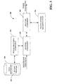
Referring now to FIG. 1, a system 100 that determines timing parameters relating to a route within a traffic system and/or one or more tasks is illustrated. The system 100 can reside within a server, be distributed across several servers, and/or reside within a client. The system 100 includes a receiver component 102 that receives a request for directions from a user. The request can be provided through utilization of a web browser and templates associated therewith, through a microphone, keypad, or any other suitable input device. The request for directions can include at least two points; a beginning point and a destination point of a journey. The points can correspond to addresses, cities, monuments, regions, landmarks, airports, or any other suitable point.
The receiver component 102 is communicatively coupled to an analysis component 104 that is employed to determine timing parameters associated with the request for directions. In more detail, the analysis component 104 can determine timing parameters associated with the request for directions that are based at least in part upon when the journey will be undertaken. In a specific example, a user can request directions from a beginning point and an ending point, and the analysis component 104 can output timing parameters such as “The journey will take approximately thirty minutes of driving time if the journey begins in five minutes. The journey will take approximately forty five minutes if the journey begins in one hour. The journey will take approximately twenty minutes if the journey begins in five hours.” Thus, the analysis component 104 enables a user to minimize drive time by providing different expected travel times given different times with respect to starting the journey. For instance, the analysis component 104 can inform a user when the journey would be expected to take a least amount of time.
To determine the timing parameters, the analysis component 104 can access a traffic system representation 106, which can be a context-sensitive representation. In other words, in contrast to conventional traffic system representations utilized by route planning applications, the traffic system representation 106 can alter as context changes. In a particular example, the traffic system representation can be and/or include a weighted graph, where nodes of the graph represent intersections, edges represent road segments between the intersections, and weights associated therewith represent average travel speeds for the road segments/intersections. The weights can alter as context alters. For instance, a first weight can be provided for a road segment at a first time of day and a second weight can be provided to the same road segment at a second time of day. Thus, the traffic system representation 106 can represent how traffic flows alter given different times of day (e.g., rush hour versus non-rush hour), days of week (e.g., weekday versus weekend), weather conditions (e.g., raining versus sunny), and other suitable contextual data. Still further, the representation 106 can include representations of traffic flows at certain road segments, wherein such flows can be probability distributions over flows and these probability distributions can be a function of contextual observations such as time of day, day of week, calendar information, flows seen at earlier times, flows in other parts of the traffic system, etc.
To determine when a user would make the journey in a least amount of time, the analysis component 104 can provide different contexts to the traffic system representation 106, thereby altering weights of nodes and edges therein. The analysis component 104 can then locate a route between the two provided points with a lowest total weight, and can determine an expected time based at least in part upon the total weight. Pursuant to an example, this can be done for increments of time. For instance, the analysis component 104 can provide expected times for the journey for each thirty minute time increment. The analysis component 104 can then cause the timing parameters to be displayed to the user in any suitable order (e.g., from departure times that are expected to require a least amount of time to departure times that are expected to require the most amount of time). The analysis component 104 can also take into account preferences about time for leaving, travel time, and arrival time in relationship to target arrival times, e.g., per events starting, and suggest a departure time and ideal route that maximizes a user's expected utility, including the user's risk preference (risk seeking or risk aversion).
Furthermore, the analysis component 104 can output time ranges with respect to an expected time for a journey given different times that the journey will be undertaken. Additionally, the analysis component 104 can output probabilities with respect to travel times. Pursuant to one example, the analysis component 104 can output that, if the user begins the journey in an hour, there is an eighty percent probability that the journey will take between twenty five and thirty five minutes. These probabilities can be based upon historic data as well as current state of a traffic system (e.g., as determined from one or more sensors, traffic reports on web pages or radio stations, . . . ). Further, the analysis component 104 can output a mean time or any other suitable timing information associated with the requested directions. Therefore, a user requesting directions can determine with some degree of certainty how long a trip will take as context changes. As stated above, while described with respect to traffic, the concepts underlying the system 100 can be applied to various applications. For instance, the traffic system representation 106 can be manipulated to represent bus lines, drive through lines, walking areas, time associated with cooking meals, etc.
With more detail with respect to the traffic system representation 106, flows (e.g., a manner in which traffic is moving or expecting to move) at road segments can be represented by probability distributions over flows and these probability distributions can be a function of contextual observations such as time of day, day of week, calendar information, flows seen at earlier times, and/or flows in other parts of the traffic system. Probabilistic forecasting models can be trained, wherein the models employ one of multiple forecasting methods that take current flows across a traffic system and compute forecasts about future flows on the traffic system, where predictions for future flows can be targeted at different times in the future. Beyond the flows, the times until particular states are reached can be predicted by the analysis component 104, such as the time until a flow becomes significantly slowed or until a jammed region of the traffic system will likely open up to flow at some level of motion. One of several discriminative or generative statistical methods can be employed for prediction and forecasting over time. These methods include statistical classifiers such as support vector machines, the use of Bayesian structure search within the realm of Bayesian machine learning, the learning and usage of dynamic Bayesian networks and related Hidden Markov Models, Continuous Time Bayesian Networks (CTBNs), and families of time-series methods such as those employing temporal Bayesian models, and models known as ARMA and ARIMA forecasting models.
Also, the analysis component 104 can utilize probabilistic models, including dynamic Bayes networks, continuous time Bayes networks, Hidden Markov models, and various time-series forecasting models to take histories and current states of traffic flows and project them into the future, considering those flows as well as potential contexts such as time of day, day of week, weather, etc. Such models can be used in connection with computing travel times for a trip ahead of time in a manner that takes into consideration estimates or predictions of the time it will take to get to each segment of a trip. In such an approach, the estimate/predicted time required to progress through each segment of a route (as determined by the analysis component 104) can be computed based upon a consideration of flows at each portion of the route at a time when the driver is expected to arrive at those downstream routes, considering the time of day and day of week and traffic flows (predicted or sensed) at a starting time and, optionally, at later times during a trip. Probabilistic forecasting methods employed by the analysis component 104 can be used to provide such flows at later times for computation of an overall travel time associated with a route starting at some particular time.
In connection with predicting the travel times, the analysis component 104 can reason about until major transitions in traffic flows, e.g. from a time that a road segment is jammed until the jam melts away into a free-flowing traffic flow). For instance, the analysis component 104 can predict expected travel times for routes at different starting times by considering the likelihood that each jammed segment will remain jammed or when it will open when it is reached as a driver as they progress over a route (and vice versa). Thus, the probability that each portion of a road segment will be jammed as a driver is expected to reach such segment can be determined, and such probability can be propagated forward for determining probabilities associated with states of a next road segment in a route. In other words, the analysis component 104 can compute mean times required for a route starting at a given time by considering cascades of probabilities and searching through all possibilities, considering the probabilities of each state and summing over all situations to compute an expected travel time. This computation can be completed for different feasible routes and different feasible starting times, and computation can be searched over to find an optimal starting time and route (given a context and/or observed real-time or recent situation). The analysis component 104 can consider various contextual events in undertaking the aforementioned computation, including occurrence of major events (e.g., sporting events, cultural events), weather, sensed and/or inferred traffic flows, accidents, traffic reports in natural language, closures, historical information, etc. The cascading search strategy can be utilized to compute actual driving times in different contexts and use of such as part of a search to identify best routes and/or best starting times and routes.
Still further, given different overall durations of travel times for various contexts, the analysis component 104 can reason about an optimal time to initiate travel between two or more points based on background statistics (e.g., historical data) and/or on real-time observations within a traffic system. For example, given certain statements in the request for directions, such as travel duration and arrival times, different starting times and routes can be generated with a consideration of such preferences. For example, a driver may state a need to arrive with a particular probability by a certain amount of time (or a cost of delayed arrival where cost starts to accrue at a particular time) and also state that driving time is desirably minimized. In another example, a user can provide a utility model that provides a cost of total driving time and of being late (or early) to an appointment and have an optimization system compute a best time to leave and a best route to take to minimize the expected cost to the user under uncertainty. For instance, a user may assert that they do not wish to leave on a route at times when leaving would allow them to arrive earlier on average because of likely clearing of traffic jams.
Numerous manners to express preferences that take as arguments such goals as total driving time, total driving distance, time until leaving for a trip, time until arriving, etc are contemplated and intended to fall under the scope of the hereto-appended claims. For instance, individuals may wish to express preferences about how much time they would like to have before a meeting or appointment starts, or make such assertions with a probabilistic inference. For instance, a driver may assert to a route planning system, “I would like to leave as late as possible yet arrive at a destination with at least thirty minutes to spare with a 90% chance of such occurring.” More generally, people can value their current time, time before leaving for a trip, time while driving, and time after arrival with different values or different rates. Individuals may wish to assign a cost as a function of how near to the start of an event that they arrive, and also specify a model that indicates the cost of being late as a function of how late they arrive after a deadline such as a meeting starting point.
The system 100 (and other systems/methods described herein) can be utilized in various manners. For instance, the system 100 can be an alerting system that informs a driver as to when to leave while taking a trip. Additionally, the system 100 can be employed to generate recommendations that inform to perform a task rather than to start or continue a trip so as to make ideal use of the user's time (e.g., when there is a list of pending goals and waiting and/or getting other things done would be a better use of time than sitting in traffic). Additionally, advertisements can be sold and rendered to a user given timing information associated with a route (e.g., when it is best that a user starts a route later and can undertake a task that takes about the right time for traffic to become free-flowing). Still further, the system 100 can be utilized to generate recommendations for a time to start travel given a preference. Moreover, the system 100 can be utilized in connection with an alarm clock that has access to a user's appointments and can wake the person up later or earlier depending upon predicted traffic flows (based upon the analysis as described above).
In summary, the system 100 described herein can search for ideal routes between points as well as starting times between routes, and based upon context the analysis component 104 can identify candidates for both a route to travel over and a starting time that maximizes a user's expected utility and/or minimizes overall cost to a user. For instance, a Dykstra search algorithm, an A* search algorithm, and/or a variant thereof can be utilized to perform route planning while considering contextual events (e.g., time of day, day of week, month, weather, . . . and a start time or a range of start times where the user is expected to reach certain portions of a possible routes. The search can be performed for multiple start times, and the analysis component 104 can select an optimal start time and route by minimizing expected cost to the user.
The cost of traveling over a route at a certain start time with respect to a user can be a function of the start time (e.g., the amount of time that a user can use for a different task before departing), driving time, and expected time of arrival, including relation between arrival time to a time that a planned meeting or appointment is scheduled to begin. To this end, a utility (or cost model) can be considered by the analysis component 104, where utility can be a function of time available before departing, expected travel time, and expected time to arrive before/after a target arrival time). When there are uncertainties, the analysis component 104 consider probabilities of different traffic flows and arrival times in connection with minimizing the expected cost of a route with respect to the user.
Thus, a representation and manner for instantiating a representation of a user's preferences about time and travel are considered, both in the general case and for a certain task at hand. For instance, a system/interface (such as that shown with respect to FIG. 13) can receive statements about preferences regarding different times for leaving, cost of travel time, and time of arriving in relation to target arrival times (e.g., per events starting). These statements can be considered by the analysis component 104 in connection with determining an optimal journey start time and an ideal route, wherein such selection maximizes a user's expected utility or minimizes an overall expected cost to the user, including the user's risk preference (risk seeking or risk aversion).
Now turning to FIG. 2, a system 200 that facilitates determining timing parameters for a particular route is illustrated. The system 200 includes the receiver component 102 that receives a route from a user (rather than a request for directions). In this instance, the user may have a preferred route that they would rather take over all other available routes. Similarly, the user may have been provided directions from another individual, and they prefer not to deviate from the directions. The analysis component 104 can receive the route and provide it to a route analyzer 202. The route analyzer 202 can access the traffic system representation 106 and analyze the provided route in connection with changing contexts. For instance, as described above, the traffic system representation 106 can include a weighted graph with edges and nodes. The route can be mapped to the edges and nodes of the traffic system representation 106, and weights associated with the route can be analyzed given different contexts. Pursuant to one example, the route analyzer 202 can determine time parameters associated with the provided route over the course of several hours, wherein timing parameters are determined for each hour. Thus, the analysis component 104 can output timing parameters similar to the following: “If you leave now, the journey will take thirty minutes, if you leave in one hour, the journey will take forty-five minutes, if you leave in two hours, the journey will take twenty five minutes.” Granularity and number of timing parameters associated with the route can be pre-determined by a user, determined through analysis of a device (not shown) that receives the timing parameters, or any other suitable manner for determining a number of timing parameters and how to display such parameters.
Referring now to FIG. 3, a system 300 that facilitates providing a user with timing parameters relating to a journey over various contexts is illustrated. The system 300 includes the receiver component 102 that receives a request for directions, wherein the directions can include a point of beginning and a destination point. The system 300 can additionally include a profile matching component 302, which can analyze driving preferences associated with the initiator of the request and map the driver to one or more driving profiles 304 within a data repository 306. The matching of the driver to a profile can be accomplished through a variety of means. For instance, sensors can be associated with the driver's vehicle, thereby enabling tracking of the driver's preferred routes (e.g., scenic routes over highway routes), average speeds given posted speed limits and traffic congestion, and the like. Data accumulated from the sensors can be analyzed in connection with profiling the driver. In another example, the driver may have previously provided answers to a questionnaire that is utilized to profile the driver. Still further, demographic information associated with the driver can be utilized to assign one or more of the profiles 304 to the driver. Therefore, it is understood that any suitable manner of profiling the driver with respect to their driving preferences is contemplated.
The driving profiles 304 can include profiles that are based upon demographics, monitored driving preferences, and the like. For example, drivers at or near retirement age may not wish to travel over highways associated with a significant amount of traffic congestion, and will increase travel time to avoid such highways. Drivers in their twenties, however, may be more willing to travel over such highways to reduce travel time. Drivers' typical areas of driving can also be indicative of driving preferences, as individuals from small towns may be less likely to travel over busy roads proximate to a large city than those who typically drive in large cities. Thus, numerous profiles can be defined that map to how different users prefer to drive.
The receiver component 102 can receive a profile that is associated with the driver, and the traffic system representation 106 can be updated based at least in part upon the profile assigned to the driver. For instance, a profile can be assigned to a driver that does not wish to travel over highways. Thus, merges and road segments that are associated with highways can be assigned a greater weight while road segments associated with scenic routes are provided a lower weight. The alteration of weights is beneficial when a user is not familiar with a region but still wishes to drive according to their preferences. Therefore, rather than the analysis component 104 locating a route that is associated with the least amount of travel time given different contexts, the analysis component 104 can determine a route that accords to user driving preferences and the request for directions. The analysis component 104 can then determine temporal parameters associated with a route that is customized for the initiator of the request over different contexts. For example, the analysis component 104 can output “If it is snowing and you depart in thirty minutes, your journey will be forty minutes. If it is not snowing and you depart in thirty minutes, your journey will be thirty minutes.” Thus the analysis component 104 can output estimated travel times given a variety of different contexts.
Referring now to FIG. 4, a route planning system 400 that outputs timing information associated with routes as context changes is illustrated. The system 400 includes the receiver component 102. Rather than receiving a beginning point and end point, however, in this example system the receiver component 102 receives multiple locations, where order that the locations are to be visited may not be of importance. For example, an individual running errands can provide the receiver component 102 with multiple locations associated with the errands. For instance, an individual may need to go to a post office, a grocery store, a hardware store, and a school in one trip. The individual, however, may not be aware of a best sequence to visit the multiple locations.
A route generator component 402 can be communicatively coupled to the receiver component 102, and can be employed to generate optimal routes given different departure times. Pursuant to one example, the route generator component can include a dialog component 404 that undertakes a dialog with the user to obtain timing information relating to the input locations. For instance, the dialog component 404 can ask a user the hours of operation of each of the multiple locations (e.g., when they open for business and close). The dialog component 404 can additionally ask the user an amount of time the user expects to stay at each location. For instance, the user may expect to be at the post office for ten minutes and at the grocery store for an hour. Additionally or alternatively, a searching component (not shown) can be employed to automatically determine operating hours of a subset of locations being visited by the user. For example, web sites associated with the multiple locations received by the receiver component 102 can include hours of operations, and the search component can automatically determine such hours. Additionally, the route generator component 402 can output directions or a route to a user, including when the user should begin travel with a probability of arriving within a certain time range of an entered time, based upon costs to the user of arriving late at a point of destination.
The timing information relating to the multiple locations can then be provided to the analysis component 104, which accesses the traffic system representation 106 to determine a best sequence to visit the multiple locations (given timing information provided by way of the dialog component 404), routes between the locations, and expected travel time of the routes (individually and/or in totality). Pursuant to a particular example, the route generator component 402 can output “If the journey begins in a half hour, the journey will be approximately four hours, and the locations should be visited in the following order: Location A, Location B, Location C. If the journey begins in two hours, the journey will be approximately four and a half hours, and the locations should be visited in the following order: Location C, Location A, Location B.” It is understood that this is but one example of operation of the system 400, wherein such example is provided only for illustrating operation of the system 400 (and is not intended to limit the scope of the claimed subject matter).
Turning now to FIG. 5, a route planning system 500 is illustrated. The system 500 includes the receiver component 102 that receives a request for directions, wherein such request includes at least a beginning point and a destination point. The receiver component 102 can additionally be communicatively coupled to a plurality of sensors 502-506 that are utilized to determine a state of a traffic system (or other suitable system where the concepts described herein can be employed). The sensors 502-506 can include pressure sensors within road segments that can be utilized to determine rate of traffic flow and/or number of vehicles within a region. The sensors 502-506 can additionally be associated with web sites that describe traffic events, radio stations that monitor traffic within a region, weather sensors, such as barometers and/or thermometers, a broadcasting station associated with weather, or any other suitable sensor that can be utilized to describe a state of a traffic system. Additionally, the sensors 502-506 can include sensors associated with individual automobiles, such as GPS receivers, speedometers, accelerometers, etc. The receiver component 102 can be configured to continuously receive data from the sensors 502-506 (and not just when the request for directions is received).
Data from the sensors can be provided to an updating component 508, which can be employed to update the traffic system representation 106 based upon the sensed data. For example, traffic systems are not static entities; rather, they are subject to change over time. In particular, construction over certain road segments can cause a traffic system and traffic flows to drastically alter. Similarly, completed construction (e.g., a road changing from a two-lane road to a four-lane road) can cause traffic flows of a road segment (and related road segments) to change. These changes can be reflected within data from the sensors 502-506. The updating component 508 can thereafter update the traffic system representation based at least in part upon the received data. For example, weights associated with edges can be altered given collected data from the sensors 502-506.
The analysis component 104 is communicatively coupled to the receiver component 102, and analyzes the traffic system representation 106 based at least in part upon the received directions. As described above, the analysis component 104 can output timing parameters related to the requested directions. For instance, the analysis component 104 can inform the user of an approximate length of time the journey between the beginning point and the end point will take given various start times. Additionally, the analysis component 104 can output directions between the provided points.
Now referring to FIG. 6, a system 600 that facilitates delivering expected travel times to a portable device is illustrated. The system 600 includes the receiver component 102, which had received a request for directions between two points or a request for estimated travel time along a route. The receiver component 102 may have received the request from a portable device 602 or other suitable device (e.g., a desktop computer). The portable device 602 can be any suitable device that can maintain a connection to a network, such as a personal digital assistant, a smart phone, a cellular phone, a laptop computer, and the like. The receiver component 102, as before, is communicatively coupled to the analysis component 104, which accesses the traffic system representation 106 and outputs estimated time parameters relating to a journey undertaken by a user. As described above, the analysis component 104 can output different estimated travel times for the journey given various start times and contexts (e.g., day of the week, time of the day, . . . ).
The portable device 602 can include sensors 604, which can be location-sensors, speed sensors, or other suitable sensors. With more specificity, the sensors 604 can include a GPS receiver, a speedometer, and an accelerometer. During a journey, data from the sensors 604 within the portable device 602 can be provided to the receiver component 102, which in turn provides such data to the analysis component 104. The analysis component 104 can analyze the traffic system representation 106 in light of the information from the sensors 604, and can provide updated time parameters to the portable device 602. In other words, the analysis component 104 can provide more refined timing parameters while the user is traveling. Pursuant to a specific example, the sensors 604 can include a GPS receiver which indicates that the user is on a certain road segment within a traffic system. This location information can be provided to the analysis component 104, which can access the traffic system representation 106 in view of such location and current context. The analysis component 104 can then update timing parameters associated therewith (e.g., from this point, the journey is expected to take twenty minutes). The portable device 602 can include a graphical user interface 606 that is employed to display the updated timing parameters to a user. Additionally or alternatively, the portable device can output audio that indicates when the journey will be complete.
Referring now to FIG. 7, a system 700 for building a robust traffic system representation is illustrated. The system 700 includes a data repository 702 that includes sensed time-series data 704, wherein such data can be collected from a plurality of drivers as they travel through a traffic system. For example, the sensed time-series data 704 can be obtained by associating location/velocity-determining sensors (such as GPS receivers) with a plurality of drivers in a traffic system (e.g., a metropolitan traffic system). As data is generated from the sensors, such data can be associated with time-stamps. Thus, trace logs for each respective driver associated with the location-determining sensor(s) are generated and can be placed within the sensed time-series data 704. Additionally, the sensors can be configured to record/output data only when a vehicle is in motion, and can automatically cease recording/outputting after the vehicle is immobile for a threshold time and/or when the vehicle is shut off. The sensors can again record/generate data when the vehicle associated therewith begins to travel. A segmentation component 706 can be employed to discern when individual journeys stop and start. As sensors associated with automobiles stop recording when the automobiles stop moving for a threshold amount of time, most (but not all) individual journeys taken by the drivers can be identified by the segmentation component 706 through reviewing time gaps that appear in the sensor logs.
Some situations exist, however, where it may not be easy to discern where a journey started and stopped. For example, a driver may stop for a short period of time to drop off a passenger. To locate such situations, for instance, the segmentation component 706 can analyze logs within the sensed time-series data to determine when a loop has been made (e.g., from location A to location B to location A). If the segmentation component 706 detects a loop, then a segmentation point can be chosen at a point in the loop that is physically furthest from where the loop closes.
The traffic system representation 106 can be built/defined based at least in part upon the sensed time-series data 704, and can be or include a graph, where nodes in the graph represent intersection of roads and edges represent road segments. A single road may be represented by multiple edges, as each road segment (the smallest unbroken portion of a road between two intersections) can be a separate edge in the graph. Additionally, the edges and nodes can be associated with latitudes and longitudes of roads that they represent. Once the sensed time-series data 704 has been segmented into individual journeys, such journeys can be “snapped” to the traffic system representation 106 through any suitable manner.
Once the trace logs are mapped into road segments, a speed analysis component 710 can associate different weights to edges/nodes within the graph of the traffic system representation 106 over different times. For example, the speed analysis component 710 can learn time-dependent traffic speed for roads by breaking days of the week into multiple categories and breaking such categories into several time slices. For purposes of illustration, it can be assumed that the speed analysis component 710 breaks the days of the week into two categories: weekdays and weekends. Such categories can then be broken into 96 time slices: 15-minute blocks of time covering 24 hours of the day. It is understood, however, that the speed analysis component 710 can create categories associated with any sort of contextual data. For instance, the speed analysis component 710 can create categories based upon weather conditions, holidays, and the like.
Continuing with the above example, the speed analysis component 710 can learn a separate average speed for each time-of-day and weekday/weekend breakdown by examining each pair (A, B) of consecutive GPS points in snapped traces. The average speed of a driver between each pair can be calculated, and the speed can be utilized to create a running average for every road segment traversed to get from A to B. Speed measurements can be applied to the running average associated with a block of time whose time characteristics match those of timestamps of collected data involved in the speed calculation. Thus, the speed analysis component 710 can determine speeds associated with road segments in various categories (time of day, day of week, . . . ). The speed analysis component 710 can then associate such data with the traffic system representation 106, such that edges and nodes are weighted based upon the collected data.
It can be discerned, however, that it may be impossible to obtain data for every road in a traffic system over every category. Thus, road speeds can be generalized given known road speeds of “similar” road segments. In more detail, a generalizer component 712 can analyze the traffic system representation 106 and provide speed values to road segments that are not associated with collected data for each category. For instance, for road segments and time segments where no data is available, the generalizer component 712 can assign the speed that is associated with the same road segment at an adjacent time block. If there is no speed associated with an adjacent time block, the generalizer component 712 can assign the segment a speed from a similar road and/or a system-wide average of speeds from similar roads, where similarity can be defined by road class within the traffic system representation 106. Additionally, similarity can be determined by analyzing speed limits, geographic proximity of road segments, geographic location of road segments, and the like. Still further, if similar roads cannot be located and/or if a system-wide speed average is unavailable, the speed for a time segment can be defined as the posted speed limit. Moreover, the generalizer component 712 can utilize machine-learning techniques/systems to learn patterns/correlations within the traffic system representation 106 and assign average road speeds to road segments based at least in part upon learned patterns, correlations, and/or trends.
Referring now to FIGS. 8-10, methodologies in accordance with the claimed subject matter will now be described by way of a series of acts. It is to be understood and appreciated that the claimed subject matter is not limited by the order of acts, as some acts may occur in different orders and/or concurrently with other acts from that shown and described herein. For example, those skilled in the art will understand and appreciate that a methodology could alternatively be represented as a series of interrelated states or events, such as in a state diagram. Moreover, not all illustrated acts may be required to implement a methodology in accordance with the claimed subject matter. Additionally, it should be further appreciated that the methodologies disclosed hereinafter and throughout this specification are capable of being stored on an article of manufacture to facilitate transporting and transferring such methodologies to computers. The term article of manufacture, as used herein, is intended to encompass a computer program accessible from any computer-readable device, carrier, or media.
Referring specifically to FIG. 8, a methodology 800 for outputting timing parameters associated with a route is illustrated. The methodology 800 starts at 802, and at 804 a request for directions between two points is received. For instance, the request can be received over a network such as the Internet through employment of a web browser. Any suitable manner for receiving the request, however, is contemplated and intended to fall under the scope of the hereto-appended claims.
At 806, a traffic system representation is accessed at varying contexts. More particularly, the traffic system representation can be or include a weighted graph that represents a traffic system, where nodes represent intersections and edges represent road segments between the intersections. The nodes and/or edges can be weighted based at least in part upon expected travel time associated with the intersections/road segments that the nodes and edges represent. Moreover, the weights can change as context alters. Thus, for instance, a weight for a road segment at 8:00 a.m. on a Friday may be quite different from a weight of a road segment at noon on a Saturday. Different weighting over different contexts represents traffic flows in a traffic system, which can drastically alter with different contexts. Pursuant to one example, the traffic system representation can be accessed at various time contexts. At 708, timing parameters associated with different departure times with respect to a route that accords to the request for directions are output. Pursuant to an example, the timing parameters can include how long travel can be expected to take if travel is begun at various times (e.g., if started now, the journey will take two hours, if started in an hour, the journey will take two and a half hours, . . . ). The methodology 800 then completes at 810.
Now turning to FIG. 9, a methodology 900 for determining when a journey should be initiated to result in minimal travel time is illustrated. The methodology 900 starts at 902, and at 904 a request for directions is received. At 906, the initiator of the request is analyzed. For example, driving habits of the initiator of the request can be determined by analyzing collected data relating to travel of the initiator of the request. For example, such user's automobile can be associated with a GPS receiver, such that location data, speed data, and the like can be collected and analyzed with respect to the user. Furthermore, demographic information associated with the user can be analyzed. At 908, a driving profile is assigned to the initiator of the request based at least in part upon the analysis. For example, several profiles can be created and defined that adequately represent detailed driving preferences of a subset of the general driving population. For example, a profile can represent drivers who are willing to extend their journey to avoid merges onto busy freeways.
At 910, directions are determined based at least in part upon the assigned profile. Thus, continuing with the above example, the driving directions will not include a merge onto a busy freeway, even if such merge would result in the least amount of travel time. At 912, a time to begin the journey that would result in a least amount of travel time is output. While shown as separate acts, the acts 910 and 912 can occur in conjunction. For example, directions can depend upon what time the user will travel, while an optimal time to begin a journey is dependent upon the selected route. Furthermore, the optimal time to begin a journey can be confined to a particular window of time. For instance, driving at 3:00 a.m. may result in a fastest journey; however, the user may wish to be sleeping at such time. Therefore, for example, a time window of between 8:00 a.m. and noon can be provided. The output time to begin the journey (and directions for the journey) can then be confined within the time window. The methodology 900 ends at 914.
Turning now to FIG. 10, a methodology 1000 for outputting different optimal routes for different start-times of a journey is illustrated. The methodology 1000 starts at 1002, and at 1004 multiple locations are received. The multiple locations can include a beginning and ending point, wherein the beginning and ending point may be the same geographic point. Pursuant to an example, the multiple locations can relate to errands that are desirably run, such as a trip to the post office, the grocery store, a school, a clothing store, etc. At 1006, timing parameters associated with the multiple locations are received. For instance, the timing parameters can include operating hours of businesses or stores as well as an amount of time that the user expects to reside at the received locations. Continuing with the above example, the user can indicate that the post office will take approximately ten minutes, the grocery store will take approximately an hour, the school will take approximately thirty minutes, and the clothing store will take approximately forty five minutes.
At 1008, a traffic system representation is analyzed given the locations and timing parameters. As described above, the traffic system representation can include or be a weighted graph that comprises representations of intersections and road segments. These representations can be weighted according to expected travel time associated therewith, and the weights can change as time of day, day of week, weather conditions, and the like alter. At 1010, optimal routes for different times of starting the journey can be output to the user. For instance, if the journey is begun at 10:00 a.m., it may be optimal to visit the clothing store first, followed by the grocery, followed by the post office, and finally followed by the school. Moreover, an estimated time for undertaking the entire journey can be provided to the user. If, however, the journey is begun at noon, it may be optimal to visit the post office first, followed by the grocery, followed by the school, and finally followed by the clothing store. These start times for the journey and estimated time for completing the journey can greatly aid a user in planning for trips and/or running errands. The methodology 1000 then ends at 1012.
Referring collectively to FIGS. 11 and 12, screenshots 1100 and 1200 of a map overlaid with data points associated with location-sensors in automobiles is illustrated. The screenshot 1100 shows a high-level view of a metropolitan area where data has been collected, and the screenshot 1200 includes a more detailed illustration of collected data points overlaying a map. These data points can be associated with a plurality of different drivers over time. It can also be discerned upon viewing the screenshot 1200 that the data points often do not map to roadways, even though most of such data points were taken from vehicles on such roadways. Therefore, it is important to carefully “snap” these data points to roadways to enable creation of a robust traffic flow representation over different contexts. In one example, a Hidden Markov Model can be utilized in connection with snapping data points to associated road segments.
FIG. 13 illustrates a 24/7 cost-of-time assessment palette 1300, allowing users to sweep out regions of low, medium, and high background costs of time, by time of day and day of week, and to associate a dollars per hour rate with each state. Thus, users can value their time, and such valuation can be input into the analysis component 104 (FIG. 1), for example, to enable determination of an optimal route. As an example, users can be asked to assign costs for being late to appointments, valuation for time while driving, social and coordinative costs of being late for a meeting: users can be allowed to enter a tardy penalty, a dollar value representing what users would be willing to pay to avoid being late, and a lateness fee, the additional cost of time for each minute they are late after that. Beyond considering appointment versus no appointment situations, a facility for splitting out meetings by calendar properties can be provided, allowing users to assign different tardy penalties and lateness fees to different kinds of meetings when requesting directions between two points. After assessment of default and meeting-centric time costs and penalties, a database of costs can be updated by time to a server, and such costs can be used in performing cost analysis during opportunistic planning. Such penalties and costs can be employed by the analysis component 104 (FIG. 1) in connection with outputting a route to a user.
With respect to learning predictive models for the cost of time, such models can introduce richer sophistication to the reasoning of a system that provides directions that are sensitive with respect to certain contexts, allowing the system to automatically assign costs of being late for different events based on the structure of appointments on a users' online calendar. In the machine learning effort, models can be built that infer (1) the probability that an appointment is associated with a low, medium, or high cost of being tardy, and (2) the probability that an appointment on a user's calendar is a valid deadline, based on multiple factors.
FIG. 14 illustrates a Bayesian network model 2400 learned from a case library of tagged appointments. The model 2400 predicts the likelihood that appointments start times are genuine deadlines for meetings and for predicting the cost function associated with tardiness. Target variables for the association of a deadline with the start of an appointment and the cost of being delayed are highlighted as circled nodes. Such a model 2400 can be useful in determining costs of being late to a particular appointment, and a system that outputs driving directions based upon context can generate routes and start times for such routes based upon the determined costs.
Turning now to FIG. 15, a graph 1500 illustrating travel times for different routes given different starting times for travel is illustrated. The graph 1500 includes a line 1502 that is representative of a first route and a line 1504 that is representative of a second route 1506. As can be discerned, travel time associated with the second route is not as volatile with respect to different start times for travel as the first route. However, to minimize an amount of driving time, the traveler may desire to travel over the first route (if able to depart at 3:30). The systems/methods described herein can inform a user when to leave if they are unconstrained with respect to departure time, which route to take if they have a constrained departure time, what route to take at what times given certain preferences (willingness to risk sitting in traffic versus being averse to such risk), etc.
In order to provide additional context for various aspects of the claimed subject matter, FIG. 16 and the following discussion are intended to provide a brief, general description of a suitable operating environment 1610 in which various aspects may be implemented. While the claimed subject matter is described in the general context of computer-executable instructions, such as program modules, executed by one or more computers or other devices, those skilled in the art will recognize that the invention can also be implemented in combination with other program modules and/or as a combination of hardware and software.
Generally, however, program modules include routines, programs, objects, components, data structures, etc. that perform particular tasks or implement particular data types. The operating environment 1610 is only one example of a suitable operating environment and is not intended to suggest any limitation as to the scope of use or functionality of the features described herein. Other well known computer systems, environments, and/or configurations that may be suitable for use with the claimed subject matter include but are not limited to, personal computers, hand-held or laptop devices, multiprocessor systems, microprocessor-based systems, programmable consumer electronics, network PCs, minicomputers, mainframe computers, distributed computing environments that include the above systems or devices, and the like.
With reference to FIG. 16, an exemplary environment 1610 that can be employed in connection with determining timing parameters related to a route output by a route planning application includes a computer 1612. The computer 1612 includes a processing unit 1614, a system memory 1616, and a system bus 1618. The system bus 1618 couples system components including, but not limited to, the system memory 1616 to the processing unit 1614. The processing unit 1614 can be any of various available processors. Dual microprocessors and other multiprocessor architectures also can be employed as the processing unit 1614.
The system bus 1618 can be any of several types of bus structure(s) including the memory bus or memory controller, a peripheral bus or external bus, and/or a local bus using any variety of available bus architectures including, but not limited to, 8-bit bus, Industrial Standard Architecture (ISA), Micro-Channel Architecture (MSA), Extended ISA (EISA), Intelligent Drive Electronics (IDE), VESA Local Bus (VLB), Peripheral Component Interconnect (PCI), Universal Serial Bus (USB), Advanced Graphics Port (AGP), Personal Computer Memory Card International Association bus (PCMCIA), and Small Computer Systems Interface (SCSI). The system memory 1616 includes volatile memory 1620 and nonvolatile memory 1622. The basic input/output system (BIOS), containing the basic routines to transfer information between elements within the computer 1612, such as during start-up, is stored in nonvolatile memory 1622. By way of illustration, and not limitation, nonvolatile memory 1622 can include read only memory (ROM), programmable ROM (PROM), electrically programmable ROM (EPROM), electrically erasable ROM (EEPROM), or flash memory. Volatile memory 1620 includes random access memory (RAM), which acts as external cache memory. By way of illustration and not limitation, RAM is available in many forms such as synchronous RAM (SRAM), dynamic RAM (DRAM), synchronous DRAM (SDRAM), double data rate SDRAM (DDR SDRAM), enhanced SDRAM (ESDRAM), Synchlink DRAM (SLDRAM), and direct Rambus RAM (DRRAM).
Computer 1612 also includes removable/nonremovable, volatile/nonvolatile computer storage media. FIG. 16 illustrates, for example a disk storage 1624. Disk storage 1624 includes, but is not limited to, devices like a magnetic disk drive, floppy disk drive, tape drive, Jaz drive, Zip drive, LS-100 drive, flash memory card, or memory stick. In addition, disk storage 1624 can include storage media separately or in combination with other storage media including, but not limited to, an optical disk drive such as a compact disk ROM device (CD-ROM), CD recordable drive (CD-R Drive), CD rewritable drive (CD-RW Drive) or a digital versatile disk ROM drive (DVD-ROM). For instance, a DVD-ROM drive can be employed in connection with reading video content from a DVD. To facilitate connection of the disk storage devices 1624 to the system bus 1618, a removable or non-removable interface is typically used such as interface 1626.
It is to be appreciated that FIG. 16 describes software that acts as an intermediary between users and the basic computer resources described in suitable operating environment 1610. Such software includes an operating system 1628. Operating system 1628, which can be stored on disk storage 1624, acts to control and allocate resources of the computer system 1612. System applications 1630 take advantage of the management of resources by operating system 1628 through program modules 1632 and program data 1634 stored either in system memory 1616 or on disk storage 1624. It is to be appreciated that the subject invention can be implemented with various operating systems or combinations of operating systems.
A user enters commands or information into the computer 1612 through input device(s) 1636. Input devices 1636 include, but are not limited to, a pointing device such as a mouse, trackball, stylus, touch pad, keyboard, microphone, joystick, game pad, satellite dish, scanner, TV tuner card, digital camera, digital video camera, web camera, remote control, and the like. These and other input devices connect to the processing unit 1614 through the system bus 1618 via interface port(s) 1638. Interface port(s) 1638 include, for example, a serial port, a parallel port, a game port, and a universal serial bus (USB). Output device(s) 1640 use some of the same type of ports as input device(s) 1636. Thus, for example, a USB port may be used to provide input to computer 1612, and to output information from computer 1612 to an output device 1640. Output adapter 1642 is provided to illustrate that there are some output devices 1640 like monitors, speakers, and printers among other output devices 1640 that require special adapters. The output adapters 1642 include, by way of illustration and not limitation, video and sound cards that provide a means of connection between the output device 1640 and the system bus 1618. It should be noted that other devices and/or systems of devices provide both input and output capabilities such as remote computer(s) 1644.
Computer 1612 can operate in a networked environment using logical connections to one or more remote computers, such as remote computer(s) 1644. The remote computer(s) 1644 can be a personal computer, a server, a router, a network PC, a workstation, a microprocessor based appliance, a peer device or other common network node and the like, and typically includes many or all of the elements described relative to computer 1612. For purposes of brevity, only a memory storage device 1646 is illustrated with remote computer(s) 1644. Remote computer(s) 1644 is logically connected to computer 1612 through a network interface 1648 and then physically connected via communication connection 1650. Network interface 1648 encompasses communication networks such as local-area networks (LAN) and wide-area networks (WAN). LAN technologies include Fiber Distributed Data Interface (FDDI), Copper Distributed Data Interface (CDDI), Ethernet/IEEE 802.3, Token Ring/IEEE 802.5 and the like. WAN technologies include, but are not limited to, point-to-point links, circuit switching networks like Integrated Services Digital Networks (ISDN) and variations thereon, packet switching networks, and Digital Subscriber Lines (DSL).
Communication connection(s) 1650 refers to the hardware/software employed to connect the network interface 1648 to the bus 1618. While communication connection 1650 is shown for illustrative clarity inside computer 1612, it can also be external to computer 1612. The hardware/software necessary for connection to the network interface 1648 includes, for exemplary purposes only, internal and external technologies such as, modems including regular telephone grade modems, cable modems and DSL modems, ISDN adapters, and Ethernet cards.
FIG. 17 is a schematic block diagram of a sample-computing environment 1700 with which the claimed subject matter can interact. The system 1700 includes one or more client(s) 1710. The client(s) 1710 can be hardware and/or software (e.g., threads, processes, computing devices). The system 1700 also includes one or more server(s) 1730. The server(s) 1730 can also be hardware and/or software (e.g., threads, processes, computing devices). The servers 1730 can house threads to perform transformations by employing the claimed subject matter, for example. One possible communication between a client 1710 and a server 1730 can be in the form of a data packet adapted to be transmitted between two or more computer processes. The system 1700 includes a communication framework 1750 that can be employed to facilitate communications between the client(s) 1710 and the server(s) 1730. The client(s) 1710 are operably connected to one or more client data store(s) 1760 that can be employed to store information local to the client(s) 1710. Similarly, the server(s) 1730 are operably connected to one or more server data store(s) 1740 that can be employed to store information local to the server(s) 1730. In one particular example, the server(s) can include a route planning system that is accessible to a client by way of a network. Users can request driving directions from the route planning system by submitting a request to the route planning system within the server by way of the client and the network, and the route planning system can then output resultant driving directions to the client. The route planning system can additionally output timing parameters associated with such route.
In an embodiment, a route planning system comprises the following computer-executable components: a receiver component that receives a request for directions between a beginning point and a destination point; and an analysis component that searches for routes between the beginning point and the destination point and identifies one or more candidate routes and one or more journey start times between the beginning point and the destination point based at least in part upon contextual information, the one or more output candidate routes and the one or more journey start times are determined as a function of at least one of expected utility to a user and expected cost incurred by the user with respect to the one or more candidate routes and the one or more journey start times.
The analysis component may consider the one or more times to start the journey and predict times when the user is expected to reach different portions of a route when identifying the one or more candidate routes and the one or more times to start the journey.
The analysis component may search over a plurality of possible journey start times in connection with identifying the one or more candidate routes and the one or more journey start times.
The expected utility is a function of at least one of time available before departing on a journey, expected time of arriving before a target arrival time, and expected time of arriving after a target arrival time.
The analysis component may determine the expected utility through receipt of user preferences regarding time of travel and departure time.
An alarm system may include the analysis component, and the alarm system alerts a driver as to one or more journey start times.
The analysis component may consider probability distributions over flows for road segments when identifying the one or more candidate routes and the one or more journey start times, wherein the distributions are a function of contextual observations that include at least one of time of day, day of week, calendar information, flows seen at earlier times, and flows in other parts of a traffic system.
The analysis component may predict future of traffic flows for road segments at times that the user is predicted to reach the road segments, and directions may be output to the user based at least in part upon the predictions.
A portable device may comprise the analysis component.
The route planning system may further comprise a profile matching component that assigns a driving profile to an initiator of the request, the analysis component determines the at least one of the expected utility to the user and expected cost incurred by the user with respect to the one or more candidate routes and the one or more journey start times based at least in part upon the assigned driving profile.
The receiver component may receive multiple intermediate points in addition to the beginning point and the destination point, the analysis component determines expected amounts of travel times with respect to traveling from the beginning point to the multiple intermediate points to the destination point for multiple contexts.
The system may further comprise a dialog component that requests time-related information from an initiator of the request with respect to the multiple intermediate points.
The analysis component may utilize at least one of a Dykstra search algorithm, an A* search algorithm, a variant of a Dykstra search algorithm, and a variant of an A* search algorithm in connection with identifying the one or more candidate routes and the one or more journey start times between the beginning point and the destination point.
In an embodiment, a methodology for determining identifying a route for travel comprises: receiving a request for directions between a beginning point and a destination point; searching for routes between the beginning point and the destination point based at least in part upon at least one of sensed and inferred contextual information; identifying at least one of a plurality of candidate routes between the beginning point and the destination point and a plurality of journey start times for a candidate route based at least in part upon the search; and selecting one or more routes to provide to a user that requests the directions based at least in part upon an estimated utility metric associated with the user requesting the directions and the at least one of a plurality of candidate routes between the beginning point and the destination point and the plurality of journey start times for the candidate route.
The methodology may further comprise: analyzing the at least one of the sensed and inferred contextual information; predicting traffic flows at road segments at future times based at least in part upon the analysis; and outputting the one or more routes based at least in part upon the predicted traffic flows.
The methodology may further comprise: analyzing driving preferences associated with the user; and determining the estimated utility metric based at least in part upon the driving preferences.
The methodology may further comprise: determining an expected cost of a journey; and outputting a route and a journey start time between the beginning point and the destination point based at least in part upon the expected cost.
The methodology may further comprise recommending to the user to perform another task prior to one of beginning a journey and continuing a journey.
The methodology may further comprise alerting the initiator of the request with respect to when to begin travel between the beginning point and the destination point given one or more of observed and predicted traffic flows.
In an embodiment, a route planning system, comprises: computer-implemented means for receiving a request for directions between a beginning point and a destination point; and computer-implemented means for determining a candidate route between the beginning point and the destination point and a candidate journey start time based at least in part upon contextual information and one or more of an expected cost of a journey over the candidate route to a user given the candidate journey start time and an expected utility of the journey over the candidate route to the user given the journey start time.
What has been described above includes examples of the claimed subject matter. It is, of course, not possible to describe every conceivable combination of components or methodologies for purposes of describing such subject matter, but one of ordinary skill in the art may recognize that many further combinations and permutations are possible. Accordingly, the claimed subject matter is intended to embrace all such alterations, modifications, and variations that fall within the spirit and scope of the appended claims. Furthermore, to the extent that the term “includes” is used in either the detailed description or the claims, such term is intended to be inclusive in a manner similar to the term “comprising” as “comprising” is interpreted when employed as a transitional word in a claim.

Claims (20)

What is claimed is:
1. A system, comprising:
a receiver component configured to receive a request for directions between an origination point and a destination point submitted by a user; and
an analysis component configured to identify a journey between the origination and destination points in response to the request, the analysis component configured to predict one or more characteristics of traffic flow at one or more road segments at one or more future times to calculate one or more estimated times corresponding to the identified journey, including being configured to predict a future time at which a road segment of the one or more road segments will be jammed;
the analysis component configured to provide the identified journey and an estimated time for undertaking the identified journey to the user, the estimated time for undertaking the identified journey selected by the analysis component to enable the user to avoid the road segment when jammed.
2. The system of claim 1, wherein the analysis component is further configured to predict a future time at which the road segment is likely to open after being predicted to be jammed.
3. The system of claim 1, wherein the analysis component is further configured to determine a time to begin the identified journey that results in a least amount of travel time for the identified journey.
4. The system of claim 1, wherein the analysis component is further configured to determine a probability for the estimated time for undertaking the identified journey.
5. The system of claim 1, wherein the analysis component is further configured to
identify, by a search, a plurality of candidate journeys between the origination point and the destination point, the search being based at least in part on contextual information,
calculate a plurality of estimated times corresponding to the plurality of candidate journeys, an estimated time of a candidate journey depending on a route of the journey, on a start time of the journey, and on at least a portion of the contextual information, and
select the journey from the plurality of candidate journeys based on the plurality of estimated times.
6. The system of claim 1, wherein the analysis component is further configured to access a traffic system representation to calculate the estimated time, the traffic system representation having the form of a weighted graph that includes a plurality of nodes, edges, and weights, each edge having a corresponding weight and each node having a corresponding weight, each node of the weighted graph representing an intersection, and each edge of the weighted graph representing a corresponding road segment.
7. A client device, comprising:
at least one processor; and
a user interface supported by the at least one processor that is configured to enable a user to submit a request for directions between an origination point and a destination point;
the user interface configured to, in response to the request, output a journey identified between the origination and destination points and an estimated time for undertaking the identified journey, the identified journey taking into account a probability of a road segment of the identified journey being open, after being in a jammed state, at an expected time to be reached by the user.
8. The client device of claim 7, wherein the user interface is further configured to provide an indication of whether the road segment is open or jammed to the user.
9. The client device of claim 7, wherein the user interface is further configured to indicate a time to begin the journey that results in a least amount of travel time for the journey.
10. The client device of claim 7, wherein the client device is configured to transmit the request to a server, and to receive the identified journey from the server in response to the transmitted request.
11. The client device of claim 7, further comprising:
an analysis component configured to identify the journey between the origination and destination points in response to the request, the analysis component configured to predict one or more characteristics of traffic flow at one or more road segments at one or more future times to calculate one or more estimated times corresponding to the identified journey, including being configured to predict a future time at which a road segment of the one or more road segments will be jammed.
12. The client device of claim 11, further comprising:
storage that stores a traffic system representation accessible by the analysis component to calculate the one or more estimated times, the traffic system representation having the form of a weighted graph that includes a plurality of nodes, edges, and weights, each edge having a corresponding weight and each node having a corresponding weight, each node of the weighted graph representing an intersection, and each edge of the weighted graph representing a corresponding road segment.
13. The client device of claim 11, wherein the analysis component is further configured to determine a probability for the estimated time for undertaking the identified journey.
14. The client device of claim 7, further comprising:
a sensor configured to determine a location of the user; and
the graphical user interface configured to indicate the determined location of the user with respect to the identified journey.
15. A computer storage medium comprising computer-executable instructions that, when executed by a processor, perform a method comprising:
receiving a request for directions between an origination point and a destination point submitted by a user;
identifying a journey between the origination and destination points in response to the request at least by predicting one or more characteristics of traffic flow at one or more road segments at one or more future times to calculate one or more estimated times corresponding to the identified journey, including predicting a future time at which a road segment of the one or more road segments will open from being jammed; and
providing the identified journey and an estimated time for undertaking the identified journey to the user.
16. The computer storage medium of claim 15, wherein said identifying a journey further comprises:
determining a probability for each of the one or more road segments of being jammed when expected to be reached by the user to determine a plurality of probabilities; and
considering the plurality of probabilities in selecting the identified journey and calculating the estimated time for undertaking the identified journey.
17. The computer storage medium of claim 15, the method further comprising:
determining a time to begin the identified journey that results in a least amount of travel time for the identified journey.
18. The computer storage medium of claim 15, the method further comprising:
determining a probability for the estimated time for undertaking the identified journey.
19. The computer storage medium of claim 15, wherein said identifying a journey further comprises:
identifying, by a search, a plurality of candidate journeys between the origination point and the destination point, the search being based at least in part on contextual information,
calculating a plurality of estimated times corresponding to the plurality of candidate journeys, an estimated time of a candidate journey depending on a route of the journey, on a start time of the journey, and on at least a portion of the contextual information, and
selecting the journey from the plurality of candidate journeys based on the plurality of estimated times.
20. The computer storage medium of claim 15, further comprising:
accessing a traffic system representation to calculate the estimated time, the traffic system representation having the form of a weighted graph that includes a plurality of nodes, edges, and weights, each edge having a corresponding weight and each node having a corresponding weight, each node of the weighted graph representing an intersection, and each edge of the weighted graph representing a corresponding road segment.
US13/922,002 2006-06-30 2013-06-19 Computation of travel routes, durations, and plans over multiple contexts Active 2026-07-10 US9008960B2 (en)

Priority Applications (2)

Application Number Priority Date Filing Date Title
US13/922,002 US9008960B2 (en) 2006-06-30 2013-06-19 Computation of travel routes, durations, and plans over multiple contexts
US14/645,197 US20150185037A1 (en) 2006-06-30 2015-03-11 Computation of travel routes, durations, and plans over multiple contexts

Applications Claiming Priority (4)

Application Number Priority Date Filing Date Title
US11/428,216 US7739040B2 (en) 2006-06-30 2006-06-30 Computation of travel routes, durations, and plans over multiple contexts
US12/691,775 US8090530B2 (en) 2006-06-30 2010-01-22 Computation of travel routes, durations, and plans over multiple contexts
US13/327,653 US8473197B2 (en) 2006-06-30 2011-12-15 Computation of travel routes, durations, and plans over multiple contexts
US13/922,002 US9008960B2 (en) 2006-06-30 2013-06-19 Computation of travel routes, durations, and plans over multiple contexts

Related Parent Applications (1)

Application Number Title Priority Date Filing Date
US13/327,653 Continuation US8473197B2 (en) 2006-06-30 2011-12-15 Computation of travel routes, durations, and plans over multiple contexts

Related Child Applications (1)

Application Number Title Priority Date Filing Date
US14/645,197 Division US20150185037A1 (en) 2006-06-30 2015-03-11 Computation of travel routes, durations, and plans over multiple contexts

Publications (2)

Publication Number Publication Date
US20130345966A1 US20130345966A1 (en) 2013-12-26
US9008960B2 true US9008960B2 (en) 2015-04-14

Family

ID=38877732

Family Applications (5)

Application Number Title Priority Date Filing Date
US11/428,216 Active 2028-04-06 US7739040B2 (en) 2006-06-30 2006-06-30 Computation of travel routes, durations, and plans over multiple contexts
US12/691,775 Active US8090530B2 (en) 2006-06-30 2010-01-22 Computation of travel routes, durations, and plans over multiple contexts
US13/327,653 Expired - Fee Related US8473197B2 (en) 2006-06-30 2011-12-15 Computation of travel routes, durations, and plans over multiple contexts
US13/922,002 Active 2026-07-10 US9008960B2 (en) 2006-06-30 2013-06-19 Computation of travel routes, durations, and plans over multiple contexts
US14/645,197 Abandoned US20150185037A1 (en) 2006-06-30 2015-03-11 Computation of travel routes, durations, and plans over multiple contexts

Family Applications Before (3)

Application Number Title Priority Date Filing Date
US11/428,216 Active 2028-04-06 US7739040B2 (en) 2006-06-30 2006-06-30 Computation of travel routes, durations, and plans over multiple contexts
US12/691,775 Active US8090530B2 (en) 2006-06-30 2010-01-22 Computation of travel routes, durations, and plans over multiple contexts
US13/327,653 Expired - Fee Related US8473197B2 (en) 2006-06-30 2011-12-15 Computation of travel routes, durations, and plans over multiple contexts

Family Applications After (1)

Application Number Title Priority Date Filing Date
US14/645,197 Abandoned US20150185037A1 (en) 2006-06-30 2015-03-11 Computation of travel routes, durations, and plans over multiple contexts

Country Status (1)

Country Link
US (5) US7739040B2 (en)

Cited By (4)

* Cited by examiner, † Cited by third party
Publication number Priority date Publication date Assignee Title
US10024675B2 (en) 2016-05-10 2018-07-17 Microsoft Technology Licensing, Llc Enhanced user efficiency in route planning using route preferences
US10408631B2 (en) 2015-07-24 2019-09-10 International Business Machines Corporation Journey planning
US10491748B1 (en) 2006-04-03 2019-11-26 Wai Wu Intelligent communication routing system and method
US11928961B2 (en) 2019-06-24 2024-03-12 Google Llc Phantom traffic jam detection and avoidance

Families Citing this family (143)

* Cited by examiner, † Cited by third party
Publication number Priority date Publication date Assignee Title
US6587781B2 (en) 2000-08-28 2003-07-01 Estimotion, Inc. Method and system for modeling and processing vehicular traffic data and information and applying thereof
US7620402B2 (en) 2004-07-09 2009-11-17 Itis Uk Limited System and method for geographically locating a mobile device
US8024112B2 (en) 2005-09-29 2011-09-20 Microsoft Corporation Methods for predicting destinations from partial trajectories employing open-and closed-world modeling methods
US8498762B2 (en) * 2006-05-02 2013-07-30 General Electric Company Method of planning the movement of trains using route protection
US7739040B2 (en) * 2006-06-30 2010-06-15 Microsoft Corporation Computation of travel routes, durations, and plans over multiple contexts
US20080004926A1 (en) * 2006-06-30 2008-01-03 Microsoft Corporation Methods and architectures for context-sensitive reminders and service facilitation
US7606662B2 (en) * 2006-07-31 2009-10-20 Nissan Technical Center North America, Inc. Traffic navigation system
JP2008083918A (en) * 2006-09-27 2008-04-10 Aisin Aw Co Ltd Navigation device
US7831386B2 (en) * 2006-11-17 2010-11-09 Ian Cummings Loop-based route finding and navigation
US20080249667A1 (en) * 2007-04-09 2008-10-09 Microsoft Corporation Learning and reasoning to enhance energy efficiency in transportation systems
US20100312464A1 (en) * 2007-05-01 2010-12-09 Chicke Fitzgerald Advice engine delivering personalized search results and customized roadtrip plans
US7865298B2 (en) * 2007-05-03 2011-01-04 Ford Motor Company System and method for providing route information to a driver of a vehicle
DE602007008690D1 (en) * 2007-05-04 2010-10-07 Harman Becker Automotive Sys Method and device for route determination
US8108144B2 (en) 2007-06-28 2012-01-31 Apple Inc. Location based tracking
US8290513B2 (en) 2007-06-28 2012-10-16 Apple Inc. Location-based services
US8385946B2 (en) 2007-06-28 2013-02-26 Apple Inc. Disfavored route progressions or locations
US8774825B2 (en) 2007-06-28 2014-07-08 Apple Inc. Integration of map services with user applications in a mobile device
US8311526B2 (en) * 2007-06-28 2012-11-13 Apple Inc. Location-based categorical information services
US9066199B2 (en) 2007-06-28 2015-06-23 Apple Inc. Location-aware mobile device
US9109904B2 (en) 2007-06-28 2015-08-18 Apple Inc. Integration of map services and user applications in a mobile device
US8332402B2 (en) 2007-06-28 2012-12-11 Apple Inc. Location based media items
US8762056B2 (en) 2007-06-28 2014-06-24 Apple Inc. Route reference
US8190359B2 (en) * 2007-08-31 2012-05-29 Proxpro, Inc. Situation-aware personal information management for a mobile device
US20090171556A1 (en) * 2007-12-31 2009-07-02 Telenav, Inc. Mutable Mobile Traffic Routing System
US8355862B2 (en) 2008-01-06 2013-01-15 Apple Inc. Graphical user interface for presenting location information
US8406998B2 (en) * 2008-02-12 2013-03-26 Cisco Technology, Inc. Traffic predictive directions
US8972177B2 (en) * 2008-02-26 2015-03-03 Microsoft Technology Licensing, Llc System for logging life experiences using geographic cues
US8015144B2 (en) 2008-02-26 2011-09-06 Microsoft Corporation Learning transportation modes from raw GPS data
US8966121B2 (en) 2008-03-03 2015-02-24 Microsoft Corporation Client-side management of domain name information
US8606517B1 (en) * 2008-04-02 2013-12-10 Strategic Design Federaton W, Inc. Travel route system and method
US8024111B1 (en) 2008-04-02 2011-09-20 Strategic Design Federation W, Inc. Travel route system and method
US9250092B2 (en) 2008-05-12 2016-02-02 Apple Inc. Map service with network-based query for search
US7519472B1 (en) 2008-05-15 2009-04-14 International Business Machines Corporation Inferring static traffic artifact presence, location, and specifics from aggregated navigation system data
US8644843B2 (en) 2008-05-16 2014-02-04 Apple Inc. Location determination
AU2008358268A1 (en) * 2008-06-25 2009-12-30 Tomtom International B.V. Navigation apparatus and method of detection that a parking facility is sought
JP5465253B2 (en) 2008-10-22 2014-04-09 トムトム インターナショナル ベスローテン フエンノートシャップ Navigation system, operation method of navigation device, and computer program
US8260320B2 (en) 2008-11-13 2012-09-04 Apple Inc. Location specific content
US9063226B2 (en) 2009-01-14 2015-06-23 Microsoft Technology Licensing, Llc Detecting spatial outliers in a location entity dataset
GB0901588D0 (en) * 2009-02-02 2009-03-11 Itis Holdings Plc Apparatus and methods for providing journey information
US20100205038A1 (en) * 2009-02-10 2010-08-12 Microsoft Corporation Travel market analysis tools
US8660530B2 (en) 2009-05-01 2014-02-25 Apple Inc. Remotely receiving and communicating commands to a mobile device for execution by the mobile device
US8670748B2 (en) 2009-05-01 2014-03-11 Apple Inc. Remotely locating and commanding a mobile device
US8666367B2 (en) 2009-05-01 2014-03-04 Apple Inc. Remotely locating and commanding a mobile device
US20110022426A1 (en) 2009-07-22 2011-01-27 Eijdenberg Adam Graphical user interface based airline travel planning
US8275649B2 (en) * 2009-09-18 2012-09-25 Microsoft Corporation Mining life pattern based on location history
US9009177B2 (en) 2009-09-25 2015-04-14 Microsoft Corporation Recommending points of interests in a region
US8762049B2 (en) * 2009-10-13 2014-06-24 Telenav, Inc. Navigation system with event of interest routing mechanism and method of operation thereof
DE102009049324A1 (en) * 2009-10-14 2011-04-21 Bayerische Motoren Werke Aktiengesellschaft Communication center i.e. central server device, for use by e.g. motorcyclist, has route recall message transmitting device transmitting route recall message to determine time or period in accordance with route request
US20110130950A1 (en) * 2009-12-02 2011-06-02 Yonatan Wexler Travel directions with travel-time estimates
US9558520B2 (en) * 2009-12-31 2017-01-31 Hartford Fire Insurance Company System and method for geocoded insurance processing using mobile devices
US20110178702A1 (en) * 2010-01-20 2011-07-21 Sony Ericsson Mobile Communications Ab Optimum travel times
US8612134B2 (en) 2010-02-23 2013-12-17 Microsoft Corporation Mining correlation between locations using location history
US9261376B2 (en) * 2010-02-24 2016-02-16 Microsoft Technology Licensing, Llc Route computation based on route-oriented vehicle trajectories
US10288433B2 (en) * 2010-02-25 2019-05-14 Microsoft Technology Licensing, Llc Map-matching for low-sampling-rate GPS trajectories
WO2011133016A2 (en) * 2010-04-20 2011-10-27 Dr Ir Tee Clarence Augustine Teck Huo Junction adaptive reactive routing (jarr) protocol for vehicular ad-hoc networks in a city environment [1-3].
GB2479794B (en) * 2010-04-23 2013-12-11 Thales Holdings Uk Plc Mobile telemetry apparatus
US8719198B2 (en) 2010-05-04 2014-05-06 Microsoft Corporation Collaborative location and activity recommendations
US9593957B2 (en) 2010-06-04 2017-03-14 Microsoft Technology Licensing, Llc Searching similar trajectories by locations
WO2011155935A1 (en) * 2010-06-10 2011-12-15 Tele Atlas North America Inc. System and method for tracking and analyzing a trip
US8645061B2 (en) * 2010-06-16 2014-02-04 Microsoft Corporation Probabilistic map matching from a plurality of observational and contextual factors
DE102010062633A1 (en) * 2010-12-08 2012-06-14 Robert Bosch Gmbh Method and device for detecting traffic signs in the vicinity of a vehicle and comparison with traffic sign information from a digital map
US9134137B2 (en) 2010-12-17 2015-09-15 Microsoft Technology Licensing, Llc Mobile search based on predicted location
US8483959B2 (en) * 2011-01-06 2013-07-09 Telenav, Inc. Navigation system with location adaptation and method of operation thereof
US20120233102A1 (en) * 2011-03-11 2012-09-13 Toyota Motor Engin. & Manufact. N.A.(TEMA) Apparatus and algorithmic process for an adaptive navigation policy in partially observable environments
US9163952B2 (en) 2011-04-15 2015-10-20 Microsoft Technology Licensing, Llc Suggestive mapping
US8489321B2 (en) 2011-06-01 2013-07-16 Garmin Switzerland Gmbh Nature event signaling
US8981995B2 (en) 2011-06-03 2015-03-17 Microsoft Technology Licensing, Llc. Low accuracy positional data by detecting improbable samples
GB2492369B (en) 2011-06-29 2014-04-02 Itis Holdings Plc Method and system for collecting traffic data
US9470529B2 (en) 2011-07-14 2016-10-18 Microsoft Technology Licensing, Llc Activating and deactivating sensors for dead reckoning
US9464903B2 (en) 2011-07-14 2016-10-11 Microsoft Technology Licensing, Llc Crowd sourcing based on dead reckoning
US9195953B2 (en) 2011-08-16 2015-11-24 Walk Score Management LLC System and method for the calculation and use of travel times in search and other applications
US8538686B2 (en) 2011-09-09 2013-09-17 Microsoft Corporation Transport-dependent prediction of destinations
US10184798B2 (en) 2011-10-28 2019-01-22 Microsoft Technology Licensing, Llc Multi-stage dead reckoning for crowd sourcing
US8564834B2 (en) 2011-10-31 2013-10-22 Xerox Corporation Printer calibration using a scanner and interpolated equivalent aim curve
FR2982061B1 (en) * 2011-11-02 2013-11-01 Alcatel Lucent ROAD TRAFFIC OPTIMIZATION SYSTEM
US20130124872A1 (en) * 2011-11-15 2013-05-16 MingXiang Shen Method of accessing a computer hardware device in a Metro user interface mode application
US9754226B2 (en) 2011-12-13 2017-09-05 Microsoft Technology Licensing, Llc Urban computing of route-oriented vehicles
US8938348B2 (en) * 2011-12-13 2015-01-20 Mitsubishi Electric Research Laboratories, Inc. Method for optimizing run curve of vehicles
US9429657B2 (en) 2011-12-14 2016-08-30 Microsoft Technology Licensing, Llc Power efficient activation of a device movement sensor module
US20130166188A1 (en) 2011-12-21 2013-06-27 Microsoft Corporation Determine Spatiotemporal Causal Interactions In Data
WO2013101045A1 (en) 2011-12-29 2013-07-04 Intel Corporation Navigation systems and associated methods
US9111442B2 (en) * 2012-03-23 2015-08-18 International Business Machines Corporation Estimating incident duration
US10275727B2 (en) * 2012-04-18 2019-04-30 International Business Machines Corporation Dynamic location-aware coordination method and system
US9772196B2 (en) 2013-08-23 2017-09-26 Cellepathy Inc. Dynamic navigation instructions
CA2877453A1 (en) 2012-06-21 2013-12-27 Cellepathy Ltd. Device context determination
US9638537B2 (en) 2012-06-21 2017-05-02 Cellepathy Inc. Interface selection in navigation guidance systems
WO2013192591A2 (en) 2012-06-22 2013-12-27 Google Inc. Ranking nearby destinations based on visit likelihoods and predicting future visits to places from location history
US20140005847A1 (en) * 2012-06-28 2014-01-02 Toyota Infotechnology Center Co. Ltd. Event Control Schedule Management
US9285218B2 (en) * 2012-08-24 2016-03-15 Regents Of The University Of Minnesota Shortest travel path determination using critical start time points
US9608952B2 (en) * 2012-12-14 2017-03-28 Intel Corporation Systems and methods for user device interaction
EP2747000B1 (en) * 2012-12-20 2017-11-22 ABB Schweiz AG System and method for automatic allocation of mobile resources to tasks
DE102013000385A1 (en) * 2013-01-11 2014-07-17 Audi Ag Method for determining travel route proposal for upcoming trip, involves providing description of particular traffic event together with typical environment feature given during particular traffic event
US20140222997A1 (en) * 2013-02-05 2014-08-07 Cisco Technology, Inc. Hidden markov model based architecture to monitor network node activities and predict relevant periods
KR20140101242A (en) * 2013-02-08 2014-08-19 삼성전자주식회사 Mobile terminal and its operating method
US9863777B2 (en) * 2013-02-25 2018-01-09 Ford Global Technologies, Llc Method and apparatus for automatic estimated time of arrival calculation and provision
US9286801B2 (en) 2013-03-06 2016-03-15 International Business Machines Corporation Leveraging information for use in a traffic prediction scenario
US9336490B2 (en) * 2013-03-14 2016-05-10 Syracuse University Combinatorics method for probabilistic geolocation
US20140343974A1 (en) * 2013-05-14 2014-11-20 Google Inc. Selecting a Subset of Transit Trips Based on Time and Duration
US9212925B2 (en) 2013-06-03 2015-12-15 International Business Machines Corporation Travel departure time determination using social media and regional event information
US10971009B2 (en) * 2013-06-28 2021-04-06 International Business Machines Corporation Extracting events and assessing their impact on a transportation network
US9127957B2 (en) * 2013-10-17 2015-09-08 Cubic Corporation Interactive day planner
US10089310B2 (en) 2014-01-14 2018-10-02 Microsoft Technology Licensing, Llc Complementary and shadow calendars
JP5972301B2 (en) * 2014-02-20 2016-08-17 本田技研工業株式会社 Visit plan creation system, terminal device, and visit plan creation method
US9413707B2 (en) 2014-04-11 2016-08-09 ACR Development, Inc. Automated user task management
US20150292894A1 (en) * 2014-04-11 2015-10-15 Telecommunication Systems, Inc. Travel route
US8942727B1 (en) 2014-04-11 2015-01-27 ACR Development, Inc. User Location Tracking
US11120408B2 (en) 2014-05-06 2021-09-14 Microsoft Technology Licensing, Llc Scheduling conflict notification
US10616719B2 (en) 2014-12-12 2020-04-07 David Thomas Systems and methods for determining texting locations and network coverage
US10175054B2 (en) 2015-01-11 2019-01-08 Microsoft Technology Licensing, Llc Predicting and utilizing variability of travel times in mapping services
US9569960B2 (en) * 2015-02-24 2017-02-14 Here Global B.V. Method and apparatus for providing traffic jam detection and prediction
US9612128B2 (en) 2015-04-29 2017-04-04 Microsoft Technology Licensing, Llc Controlling travel route planning module based upon user travel preference
US9741183B2 (en) 2015-11-10 2017-08-22 Veniam, Inc Systems and methods for optimizing data gathering in a network of moving things
JP6529429B2 (en) * 2015-12-22 2019-06-12 本田技研工業株式会社 Traffic information output system and traffic information output method
US9500489B1 (en) * 2016-03-03 2016-11-22 Mitac International Corp. Method of adjusting a navigation route based on detected passenger sleep data and related system
CN107305742A (en) * 2016-04-18 2017-10-31 滴滴(中国)科技有限公司 Method and apparatus for determining E.T.A
US10151592B2 (en) * 2016-04-28 2018-12-11 Here Global B.V. Map matching quality evaluation
GB2556876A (en) * 2016-11-09 2018-06-13 Inventive Cogs Campbell Ltd Vehicle route guidance
CN108288096B (en) * 2017-01-10 2020-08-21 北京嘀嘀无限科技发展有限公司 Method and device for estimating travel time and training model
US20180218303A1 (en) * 2017-02-01 2018-08-02 Weather Build, Inc. Systems and methods for analyzing weather event impacts on schedule activities
KR20190104360A (en) * 2017-02-02 2019-09-09 닛산 지도우샤 가부시키가이샤 Memory history storage method, driving trajectory model generation method, magnetic position estimation method, and driving history storage device
US10769946B1 (en) * 2017-04-24 2020-09-08 Ronald M Harstad Incentive-compatible, asymmetric-information, real-time traffic-routing differential-advice
WO2018227389A1 (en) * 2017-06-13 2018-12-20 Beijing Didi Infinity Technology And Development Co., Ltd. Systems and methods for determining estimated time of arrival
US10437247B2 (en) 2017-08-10 2019-10-08 Udelv Inc. Multi-stage operation of autonomous vehicles
US10783778B2 (en) 2017-10-20 2020-09-22 Microsoft Technology Licensing, Llc Traffic data reconciliation and brokering
US10663313B2 (en) * 2017-12-15 2020-05-26 Google Llc Providing traffic warnings to a user based on return journey
US10612934B2 (en) * 2018-01-12 2020-04-07 General Electric Company System and methods for robotic autonomous motion planning and navigation
US10362448B1 (en) 2018-01-15 2019-07-23 David Thomas Systems and methods for determining texting locations and network coverage
US10467581B2 (en) 2018-01-19 2019-11-05 Udelv Inc. Delivery management system
CN110163405B (en) * 2018-07-23 2022-03-25 腾讯大地通途(北京)科技有限公司 Method, device, terminal and storage medium for determining transit time
US20200126123A1 (en) * 2018-10-19 2020-04-23 Google Llc Advance notification of convenient purchase points
CN109724611B (en) * 2019-01-08 2020-07-17 北京三快在线科技有限公司 Path planning method and device, electronic equipment and storage medium
CN111858786B (en) * 2019-06-06 2023-12-22 北京嘀嘀无限科技发展有限公司 System and method for providing time-of-flight confidence in path planning
US11463841B1 (en) * 2019-07-19 2022-10-04 Student Ally, Inc. System and method for monitoring and ensuring student safety
US11391588B2 (en) 2019-08-30 2022-07-19 Toyota Motor North America, Inc. Using big data to navigate vehicles at large events
JP7238714B2 (en) * 2019-09-18 2023-03-14 トヨタ自動車株式会社 Information processing device, information processing method, and program
JP6937856B2 (en) * 2020-02-13 2021-09-22 本田技研工業株式会社 Driving assistance devices and vehicles
US20210300297A1 (en) * 2020-03-27 2021-09-30 Toyota Connected North America, Inc. Vehicle systems for dynamic crowdsourced delivery
US11532059B2 (en) * 2020-04-20 2022-12-20 International Business Machines Corporation Geo-spatial analysis to determine boundaries of traffic regions and classifications of the boundaries for controlling drop-off/pick-up traffic
JP2022025229A (en) * 2020-07-29 2022-02-10 カワサキモータース株式会社 Travel route generation system, travel route generation program, and travel route generation method
SG10202007346XA (en) * 2020-08-01 2020-10-29 Grabtaxi Holdings Pte Ltd Processing apparatus and method for generating route navigation data
CN114509078B (en) * 2020-11-16 2024-02-20 中国联合网络通信集团有限公司 Navigation line recommending method and server
ES2915323A1 (en) * 2020-12-21 2022-06-21 Carrillo De Albornoz Vicente Alcaraz System and method for the assessment and optimization of the transport costs that people who share the same location support (Machine-translation by Google Translate, not legally binding)
US11933615B2 (en) * 2021-01-26 2024-03-19 Ubkang (Qingdao) Technology Co., Ltd. Estimated time of arrival calculating method and system and mobile machine using the same

Citations (107)

* Cited by examiner, † Cited by third party
Publication number Priority date Publication date Assignee Title
US5371678A (en) * 1990-11-22 1994-12-06 Nissan Motor Co., Ltd. System and method for navigating vehicle along set route of travel
US5444442A (en) 1992-11-05 1995-08-22 Matsushita Electric Industrial Co., Ltd. Method for predicting traffic space mean speed and traffic flow rate, and method and apparatus for controlling isolated traffic light signaling system through predicted traffic flow rate
US5493692A (en) 1993-12-03 1996-02-20 Xerox Corporation Selective delivery of electronic messages in a multiple computer system based on context and environment of a user
US5544321A (en) 1993-12-03 1996-08-06 Xerox Corporation System for granting ownership of device by user based on requested level of ownership, present state of the device, and the context of the device
US5606695A (en) 1994-08-11 1997-02-25 Cegelec Method of scheduling successive tasks subject only to timing constraints
US5812865A (en) 1993-12-03 1998-09-22 Xerox Corporation Specifying and establishing communication data paths between particular media devices in multiple media device computing systems based on context of a user or users
US5812069A (en) 1995-07-07 1998-09-22 Mannesmann Aktiengesellschaft Method and system for forecasting traffic flows
US5822712A (en) 1992-11-19 1998-10-13 Olsson; Kjell Prediction method of traffic parameters
US5892463A (en) * 1996-09-05 1999-04-06 Mitsubishi Denki Kabushiki Kaisha Mobile navigation system
US5933094A (en) 1995-05-05 1999-08-03 Robert Bosch GmbH Device for editing and outputting information for a motor vehicle driver
US5948040A (en) 1994-06-24 1999-09-07 Delorme Publishing Co. Travel reservation information and planning system
US5955974A (en) 1997-09-11 1999-09-21 Fujitsu Limited Information processing apparatus with transfer or arrival precaution
US5987374A (en) 1996-07-08 1999-11-16 Toyota Jidosha Kabushiki Kaisha Vehicle traveling guidance system
US6026375A (en) 1997-12-05 2000-02-15 Nortel Networks Corporation Method and apparatus for processing orders from customers in a mobile environment
US6047260A (en) 1997-06-05 2000-04-04 Attention Control Systems, Inc. Intelligent planning and calendaring system with cueing feature and floating tasks
US6119095A (en) 1996-01-22 2000-09-12 Toyota Jidosha Kabushiki Kaisha System for planning and revising an itinerary based on intended travel time and expected consumption time
US6124826A (en) 1994-10-07 2000-09-26 Mannesmann Aktiengesellschaft Navigation device for people
US6178378B1 (en) * 1998-05-23 2001-01-23 General Motors Corporation Method for operating a navigation system for motor vehicles
US6192314B1 (en) 1998-03-25 2001-02-20 Navigation Technologies Corp. Method and system for route calculation in a navigation application
US6216086B1 (en) 1991-11-01 2001-04-10 Motorola, Inc. Driver preference responsive vehicle route planning system
US6236932B1 (en) 1996-12-16 2001-05-22 Mannesmann Ag Process for completing and/or verifying data concerning the state of a road network; traffic information centre
US6240364B1 (en) 1999-02-06 2001-05-29 Daimlerchrysler Ag Method and device for providing traffic information
US6259988B1 (en) 1998-07-20 2001-07-10 Lockheed Martin Corporation Real-time mission adaptable route planner
US6282486B1 (en) 2000-04-03 2001-08-28 International Business Machines Corporation Distributed system and method for detecting traffic patterns
US20010020211A1 (en) 2000-02-14 2001-09-06 Kuniharu Takayama Navigation information presenting apparatus and method thereof
US6298302B2 (en) 1997-07-01 2001-10-02 Mannesman Vdo Navigation system for providing an optimal route from traffic messages
US20010029425A1 (en) 2000-03-17 2001-10-11 David Myr Real time vehicle guidance and traffic forecasting system
US20010030664A1 (en) 1999-08-16 2001-10-18 Shulman Leo A. Method and apparatus for configuring icon interactivity
US6314365B1 (en) 2000-01-18 2001-11-06 Navigation Technologies Corp. Method and system of providing navigation services to cellular phone devices from a server
US6317685B1 (en) * 2000-03-13 2001-11-13 Navigation Technologies Corp. Method and system for providing alternate routes with a navigation system
US6317686B1 (en) * 2000-07-21 2001-11-13 Bin Ran Method of providing travel time
US20010040591A1 (en) 1998-12-18 2001-11-15 Abbott Kenneth H. Thematic response to a computer user's context, such as by a wearable personal computer
US20010040590A1 (en) 1998-12-18 2001-11-15 Abbott Kenneth H. Thematic response to a computer user's context, such as by a wearable personal computer
US20010043232A1 (en) 1998-12-18 2001-11-22 Abbott Kenneth H. Thematic response to a computer user's context, such as by a wearable personal computer
US20020010615A1 (en) 2000-03-31 2002-01-24 Simon Jacobs Methods and systems for scheduling complex work orders for a workforce of mobile service technicians
US6353398B1 (en) 1999-10-22 2002-03-05 Himanshu S. Amin System for dynamically pushing information to a user utilizing global positioning system
US20020032689A1 (en) 1999-12-15 2002-03-14 Abbott Kenneth H. Storing and recalling information to augment human memories
US20020044152A1 (en) 2000-10-16 2002-04-18 Abbott Kenneth H. Dynamic integration of computer generated and real world images
US6381522B1 (en) 1999-02-09 2002-04-30 Hitachi, Ltd. Method for controlling a hybrid vehicle
US6381533B1 (en) 1997-10-16 2002-04-30 Navigation Technologies Corp. Method and system using positions of cellular phones matched to road network for collecting data
US20020052930A1 (en) 1998-12-18 2002-05-02 Abbott Kenneth H. Managing interactions between computer users' context models
US20020054174A1 (en) 1998-12-18 2002-05-09 Abbott Kenneth H. Thematic response to a computer user's context, such as by a wearable personal computer
US20020054130A1 (en) 2000-10-16 2002-05-09 Abbott Kenneth H. Dynamically displaying current status of tasks
US6401038B2 (en) 1999-06-28 2002-06-04 Min-Chung Gia Path planning, terrain avoidance and situation awareness system for general aviation
US6401027B1 (en) 1999-03-19 2002-06-04 Wenking Corp. Remote road traffic data collection and intelligent vehicle highway system
US20020078204A1 (en) 1998-12-18 2002-06-20 Dan Newell Method and system for controlling presentation of information to a user based on the user's condition
US20020082772A1 (en) 2000-11-15 2002-06-27 International Business Machines Corporation Route search system and route search method
US20020080155A1 (en) 1998-12-18 2002-06-27 Abbott Kenneth H. Supplying notifications related to supply and consumption of user context data
US20020083025A1 (en) 1998-12-18 2002-06-27 Robarts James O. Contextual responses based on automated learning techniques
US20020082771A1 (en) 2000-12-26 2002-06-27 Anderson Andrew V. Method and apparatus for deriving travel profiles
US20020087525A1 (en) 2000-04-02 2002-07-04 Abbott Kenneth H. Soliciting information based on a computer user's context
US20020103693A1 (en) 2001-01-30 2002-08-01 Horst Bayer System and method for aggregating and analyzing feedback
US6445968B1 (en) 1999-07-12 2002-09-03 Maharaj K. Jalla Task manager
US20020128766A1 (en) 2000-09-12 2002-09-12 Bernd Petzold Navigational system
US20020147541A1 (en) 2001-04-09 2002-10-10 Koninklijke Philips Electronics N.V. System and method for disseminating traffic information
US6480783B1 (en) 2000-03-17 2002-11-12 Makor Issues And Rights Ltd. Real time vehicle guidance and forecasting system under traffic jam conditions
US20030018521A1 (en) 2001-07-17 2003-01-23 International Business Machines Corporation Advertising based upon events reported from a GPS enabled event report system
US20030018428A1 (en) 1997-08-19 2003-01-23 Siemens Automotive Corporation, A Delaware Corporation Vehicle information system
US20030027558A1 (en) 2001-08-01 2003-02-06 Alcatel Method for executing a service for organisation of meetings for participants in a communications network, and service computer and program module for this
US20030046158A1 (en) 2001-09-04 2003-03-06 Kratky Jan Joseph Method and system for enhancing mobile advertisement targeting with virtual roadside billboards
US20030046401A1 (en) 2000-10-16 2003-03-06 Abbott Kenneth H. Dynamically determing appropriate computer user interfaces
US20030060979A1 (en) 2001-09-21 2003-03-27 International Business Machines Corporation Method and apparatus for notifying a user of an appointment
US20030065442A1 (en) 2001-09-01 2003-04-03 Touney David Sylvester Navigation system and travel coordinator with dynamic traffic data
US20030158655A1 (en) 1999-10-19 2003-08-21 American Calcar Inc. Technique for effective navigation based on user preferences
US20030182052A1 (en) 1994-06-24 2003-09-25 Delorme David M. Integrated routing/mapping information system
US20030187570A1 (en) 2002-04-02 2003-10-02 Lockheed Martin Corporation Real-time ad hoc traffic alert distribution
US6640212B1 (en) 1999-09-30 2003-10-28 Rodney L. Rosse Standardized information management system for long-term residence facilities
US6672506B2 (en) 1996-01-25 2004-01-06 Symbol Technologies, Inc. Statistical sampling security methodology for self-scanning checkout system
US6704645B1 (en) 2001-12-11 2004-03-09 Garmin Ltd. System and method for estimating impedance time through a road network
US20040059622A1 (en) 2002-09-20 2004-03-25 Mueller Erik T. Assisting people and computer programs with time and task management
US6721650B2 (en) 2001-02-23 2004-04-13 Hitachi, Ltd. Method of presuming traffic conditions by using floating car data and system for presuming and presenting traffic conditions by using floating data
US20040088107A1 (en) 2002-11-04 2004-05-06 Seligmann Doree Duncan Intelligent trip status notification
US20040102896A1 (en) 2002-11-27 2004-05-27 Thayer Peter A. Method and apparatus for providing information pertaining to vehicles located along a predetermined travel route
US6744383B1 (en) 2000-02-01 2004-06-01 At&T Wireless Services, Inc. Intelligent roadway system
US6747675B1 (en) 1998-12-18 2004-06-08 Tangis Corporation Mediating conflicts in computer user's context data
US6751549B1 (en) 2002-01-17 2004-06-15 Navigation Technologies Corporation Method and system for route calculation that avoids railroad crossings
US20040128066A1 (en) * 2001-08-06 2004-07-01 Takahiro Kudo Information providing method and information providing device
USD494584S1 (en) 2002-12-05 2004-08-17 Symbol Technologies, Inc. Mobile companion
US6796505B2 (en) 1997-08-08 2004-09-28 Symbol Technologies, Inc. Terminal locking system
US6812937B1 (en) 1998-12-18 2004-11-02 Tangis Corporation Supplying enhanced computer user's context data
US6813558B1 (en) 1999-10-25 2004-11-02 Silverbrook Research Pty Ltd Method and system for route planning
US6837436B2 (en) 1996-09-05 2005-01-04 Symbol Technologies, Inc. Consumer interactive shopping system
USRE38724E1 (en) 1991-02-01 2005-04-12 Peterson Thomas D Method and apparatus for providing shortest elapsed time route and tracking information to users
US6882930B2 (en) 2000-06-26 2005-04-19 Stratech Systems Limited Method and system for providing traffic and related information
US6909380B2 (en) 2003-04-04 2005-06-21 Lockheed Martin Corporation Centralized traffic signal preemption system and method of use
US6970131B2 (en) 2001-12-31 2005-11-29 Rdp Associates, Incorporated Satellite positioning system enabled media measurement system and method
US20050267680A1 (en) 2004-05-31 2005-12-01 Nissan Motor Co., Ltd. Navigation device and method of presenting information corresponding to travel course stage
US6983139B2 (en) 1998-11-17 2006-01-03 Eric Morgan Dowling Geographical web browser, methods, apparatus and systems
US6985810B2 (en) 2002-02-21 2006-01-10 Lockheed Martin Corporation Real-time route and sensor planning system with variable mission objectives
US7010501B1 (en) 1998-05-29 2006-03-07 Symbol Technologies, Inc. Personal shopping system
US7040541B2 (en) 1996-09-05 2006-05-09 Symbol Technologies, Inc. Portable shopping and order fulfillment system
US20060122846A1 (en) 2002-08-29 2006-06-08 Jonathan Burr Apparatus and method for providing traffic information
US20060149461A1 (en) 2004-12-31 2006-07-06 Henry Rowley Transportation routing
US20060241862A1 (en) 2003-04-03 2006-10-26 Naohiko Ichihara Navigation device, navigation method, route data generation program, recording medium containing route data generation program, and server device in navigation system
US7171378B2 (en) 1998-05-29 2007-01-30 Symbol Technologies, Inc. Portable electronic terminal and data processing system
US20070162222A1 (en) 2004-01-16 2007-07-12 Yoshinori Endo Route search method for navigation device
US20080033633A1 (en) * 2003-09-30 2008-02-07 Kabushiki Kaisha Kenwood Guide Route Search Device and Guide Route Search Method
US20080046298A1 (en) 2004-07-29 2008-02-21 Ziv Ben-Yehuda System and Method For Travel Planning
US20080109153A1 (en) 2002-03-05 2008-05-08 Andre Gueziec GPS-Generated Traffic Information
US20080165032A1 (en) 2007-01-05 2008-07-10 Samsung Electronics Co., Ltd. Apparatus and method of providing schedule and route
US7418340B2 (en) 2003-10-10 2008-08-26 Denso Corporation Navigation device
US20100063721A1 (en) 2007-02-02 2010-03-11 Thinkware Systems Corporation Travel information service system and method for providing travel information of the same system
US20100088020A1 (en) 2008-10-07 2010-04-08 Darrell Sano User interface for predictive traffic
US7698055B2 (en) 2004-11-16 2010-04-13 Microsoft Corporation Traffic forecasting employing modeling and analysis of probabilistic interdependencies and contextual data
US7706964B2 (en) 2006-06-30 2010-04-27 Microsoft Corporation Inferring road speeds for context-sensitive routing
US7739040B2 (en) 2006-06-30 2010-06-15 Microsoft Corporation Computation of travel routes, durations, and plans over multiple contexts
US8108141B2 (en) 2008-08-28 2012-01-31 Empire Technology Development Llc Intelligent travel routing system and method

Family Cites Families (26)

* Cited by examiner, † Cited by third party
Publication number Priority date Publication date Assignee Title
US6035104A (en) 1996-06-28 2000-03-07 Data Link Systems Corp. Method and apparatus for managing electronic documents by alerting a subscriber at a destination other than the primary destination
AU7703598A (en) 1997-05-30 1998-12-30 David S. Booth Generation and delivery of travel-related, location-sensitive information
WO2001063451A2 (en) 2000-02-22 2001-08-30 Classified Advertiser.Com, Inc. Remote advertising order/placement system
US8175921B1 (en) 2000-05-30 2012-05-08 Nokia Corporation Location aware product placement and advertising
GB2378560A (en) * 2001-08-08 2003-02-12 Motorola Inc Planning and optimising a passenger journey in a mass transit system
GB0220062D0 (en) 2002-08-29 2002-10-09 Itis Holdings Plc Traffic scheduling system
US7215255B2 (en) * 2003-01-21 2007-05-08 Bernard Grush Method and apparatus for a satellite positioning-based metering system for use in transport-related applications
US20040192351A1 (en) * 2003-03-31 2004-09-30 Duncan Daniel N. Method and system for mobile display of context-based advertising content
KR100811232B1 (en) * 2003-07-18 2008-03-07 엘지전자 주식회사 Turn-by-turn navigation system ? next guidance way
KR20050015912A (en) * 2003-08-14 2005-02-21 삼성전자주식회사 Navigation system using paging network and tethod for providing traffic information thereof
US20050049765A1 (en) * 2003-08-27 2005-03-03 Sacagawea21 Inc. Method and apparatus for advertising assessment using location and temporal information
CZ20032781A3 (en) 2003-10-10 2004-11-10 Secar Bohemia, A.S. Device for monitoring movement of an object especially a vehicle
US7389178B2 (en) * 2003-12-11 2008-06-17 Greenroad Driving Technologies Ltd. System and method for vehicle driver behavior analysis and evaluation
JP2005301894A (en) * 2004-04-15 2005-10-27 Matsushita Electric Ind Co Ltd Work progress management method, work progress management device and program
US8407076B2 (en) * 2004-05-14 2013-03-26 International Business Machines Corporation Accommodating preparatory work for electronically scheduled meetings
US7117083B2 (en) * 2004-06-29 2006-10-03 Intel Corporation System and method for enabling wireless traffic message passing
JP4211706B2 (en) * 2004-07-28 2009-01-21 株式会社日立製作所 Traffic information provision device
DE102004037858A1 (en) * 2004-08-04 2006-03-16 Harman Becker Automotive Systems Gmbh Navigation system with voice-controlled indication of points of interest
US20060161335A1 (en) * 2005-01-14 2006-07-20 Ross Beinhaker Routing system and method
US20060184314A1 (en) * 2005-02-14 2006-08-17 Microsoft Corporation Multi-modal navigation system and method
US7698061B2 (en) * 2005-09-23 2010-04-13 Scenera Technologies, Llc System and method for selecting and presenting a route to a user
US7486201B2 (en) * 2006-01-10 2009-02-03 Myweather, Llc Combined personalized traffic and weather report and alert system and method
US8126641B2 (en) 2006-06-30 2012-02-28 Microsoft Corporation Route planning with contingencies
US20080249667A1 (en) 2007-04-09 2008-10-09 Microsoft Corporation Learning and reasoning to enhance energy efficiency in transportation systems
US20080319658A1 (en) 2007-06-25 2008-12-25 Microsoft Corporation Landmark-based routing
US20080319660A1 (en) 2007-06-25 2008-12-25 Microsoft Corporation Landmark-based routing

Patent Citations (135)

* Cited by examiner, † Cited by third party
Publication number Priority date Publication date Assignee Title
US5371678A (en) * 1990-11-22 1994-12-06 Nissan Motor Co., Ltd. System and method for navigating vehicle along set route of travel
USRE38724E1 (en) 1991-02-01 2005-04-12 Peterson Thomas D Method and apparatus for providing shortest elapsed time route and tracking information to users
US6216086B1 (en) 1991-11-01 2001-04-10 Motorola, Inc. Driver preference responsive vehicle route planning system
US5444442A (en) 1992-11-05 1995-08-22 Matsushita Electric Industrial Co., Ltd. Method for predicting traffic space mean speed and traffic flow rate, and method and apparatus for controlling isolated traffic light signaling system through predicted traffic flow rate
US5822712A (en) 1992-11-19 1998-10-13 Olsson; Kjell Prediction method of traffic parameters
US5812865A (en) 1993-12-03 1998-09-22 Xerox Corporation Specifying and establishing communication data paths between particular media devices in multiple media device computing systems based on context of a user or users
US5611050A (en) 1993-12-03 1997-03-11 Xerox Corporation Method for selectively performing event on computer controlled device whose location and allowable operation is consistent with the contextual and locational attributes of the event
US5603054A (en) 1993-12-03 1997-02-11 Xerox Corporation Method for triggering selected machine event when the triggering properties of the system are met and the triggering conditions of an identified user are perceived
US5555376A (en) 1993-12-03 1996-09-10 Xerox Corporation Method for granting a user request having locational and contextual attributes consistent with user policies for devices having locational attributes consistent with the user request
US5544321A (en) 1993-12-03 1996-08-06 Xerox Corporation System for granting ownership of device by user based on requested level of ownership, present state of the device, and the context of the device
US5493692A (en) 1993-12-03 1996-02-20 Xerox Corporation Selective delivery of electronic messages in a multiple computer system based on context and environment of a user
US5948040A (en) 1994-06-24 1999-09-07 Delorme Publishing Co. Travel reservation information and planning system
US20030182052A1 (en) 1994-06-24 2003-09-25 Delorme David M. Integrated routing/mapping information system
US5606695A (en) 1994-08-11 1997-02-25 Cegelec Method of scheduling successive tasks subject only to timing constraints
US6124826A (en) 1994-10-07 2000-09-26 Mannesmann Aktiengesellschaft Navigation device for people
US5933094A (en) 1995-05-05 1999-08-03 Robert Bosch GmbH Device for editing and outputting information for a motor vehicle driver
US5812069A (en) 1995-07-07 1998-09-22 Mannesmann Aktiengesellschaft Method and system for forecasting traffic flows
US6119095A (en) 1996-01-22 2000-09-12 Toyota Jidosha Kabushiki Kaisha System for planning and revising an itinerary based on intended travel time and expected consumption time
US6672506B2 (en) 1996-01-25 2004-01-06 Symbol Technologies, Inc. Statistical sampling security methodology for self-scanning checkout system
US5987374A (en) 1996-07-08 1999-11-16 Toyota Jidosha Kabushiki Kaisha Vehicle traveling guidance system
US7040541B2 (en) 1996-09-05 2006-05-09 Symbol Technologies, Inc. Portable shopping and order fulfillment system
US7195157B2 (en) 1996-09-05 2007-03-27 Symbol Technologies, Inc. Consumer interactive shopping system
US7063263B2 (en) 1996-09-05 2006-06-20 Symbol Technologies, Inc. Consumer interactive shopping system
US6837436B2 (en) 1996-09-05 2005-01-04 Symbol Technologies, Inc. Consumer interactive shopping system
US5892463A (en) * 1996-09-05 1999-04-06 Mitsubishi Denki Kabushiki Kaisha Mobile navigation system
US6236932B1 (en) 1996-12-16 2001-05-22 Mannesmann Ag Process for completing and/or verifying data concerning the state of a road network; traffic information centre
US6047260A (en) 1997-06-05 2000-04-04 Attention Control Systems, Inc. Intelligent planning and calendaring system with cueing feature and floating tasks
US6298302B2 (en) 1997-07-01 2001-10-02 Mannesman Vdo Navigation system for providing an optimal route from traffic messages
US6796505B2 (en) 1997-08-08 2004-09-28 Symbol Technologies, Inc. Terminal locking system
US20030018428A1 (en) 1997-08-19 2003-01-23 Siemens Automotive Corporation, A Delaware Corporation Vehicle information system
US5955974A (en) 1997-09-11 1999-09-21 Fujitsu Limited Information processing apparatus with transfer or arrival precaution
US6381533B1 (en) 1997-10-16 2002-04-30 Navigation Technologies Corp. Method and system using positions of cellular phones matched to road network for collecting data
US6026375A (en) 1997-12-05 2000-02-15 Nortel Networks Corporation Method and apparatus for processing orders from customers in a mobile environment
US20010047241A1 (en) 1998-03-25 2001-11-29 Asta Khavakh Method and system for route calcuation in a navigation application
US6298303B1 (en) 1998-03-25 2001-10-02 Navigation Technologies Corp. Method and system for route calculation in a navigation application
US6192314B1 (en) 1998-03-25 2001-02-20 Navigation Technologies Corp. Method and system for route calculation in a navigation application
US7054742B2 (en) 1998-03-25 2006-05-30 Navteq North America, Llc Method and system for route calculation in a navigation application
US6178378B1 (en) * 1998-05-23 2001-01-23 General Motors Corporation Method for operating a navigation system for motor vehicles
US7171378B2 (en) 1998-05-29 2007-01-30 Symbol Technologies, Inc. Portable electronic terminal and data processing system
US7010501B1 (en) 1998-05-29 2006-03-07 Symbol Technologies, Inc. Personal shopping system
US6259988B1 (en) 1998-07-20 2001-07-10 Lockheed Martin Corporation Real-time mission adaptable route planner
US6983139B2 (en) 1998-11-17 2006-01-03 Eric Morgan Dowling Geographical web browser, methods, apparatus and systems
US6801223B1 (en) 1998-12-18 2004-10-05 Tangis Corporation Managing interactions between computer users' context models
US20020099817A1 (en) 1998-12-18 2002-07-25 Abbott Kenneth H. Managing interactions between computer users' context models
US20010040591A1 (en) 1998-12-18 2001-11-15 Abbott Kenneth H. Thematic response to a computer user's context, such as by a wearable personal computer
US20010040590A1 (en) 1998-12-18 2001-11-15 Abbott Kenneth H. Thematic response to a computer user's context, such as by a wearable personal computer
US6747675B1 (en) 1998-12-18 2004-06-08 Tangis Corporation Mediating conflicts in computer user's context data
US20020052930A1 (en) 1998-12-18 2002-05-02 Abbott Kenneth H. Managing interactions between computer users' context models
US20020052963A1 (en) 1998-12-18 2002-05-02 Abbott Kenneth H. Managing interactions between computer users' context models
US20020054174A1 (en) 1998-12-18 2002-05-09 Abbott Kenneth H. Thematic response to a computer user's context, such as by a wearable personal computer
US6791580B1 (en) 1998-12-18 2004-09-14 Tangis Corporation Supplying notifications related to supply and consumption of user context data
US20010043232A1 (en) 1998-12-18 2001-11-22 Abbott Kenneth H. Thematic response to a computer user's context, such as by a wearable personal computer
US20010043231A1 (en) 1998-12-18 2001-11-22 Abbott Kenneth H. Thematic response to a computer user's context, such as by a wearable personal computer
US20020078204A1 (en) 1998-12-18 2002-06-20 Dan Newell Method and system for controlling presentation of information to a user based on the user's condition
US6466232B1 (en) 1998-12-18 2002-10-15 Tangis Corporation Method and system for controlling presentation of information to a user based on the user's condition
US20020080155A1 (en) 1998-12-18 2002-06-27 Abbott Kenneth H. Supplying notifications related to supply and consumption of user context data
US20020080156A1 (en) 1998-12-18 2002-06-27 Abbott Kenneth H. Supplying notifications related to supply and consumption of user context data
US20020083025A1 (en) 1998-12-18 2002-06-27 Robarts James O. Contextual responses based on automated learning techniques
US6812937B1 (en) 1998-12-18 2004-11-02 Tangis Corporation Supplying enhanced computer user's context data
US20020083158A1 (en) 1998-12-18 2002-06-27 Abbott Kenneth H. Managing interactions between computer users' context models
US6842877B2 (en) 1998-12-18 2005-01-11 Tangis Corporation Contextual responses based on automated learning techniques
US6240364B1 (en) 1999-02-06 2001-05-29 Daimlerchrysler Ag Method and device for providing traffic information
US6381522B1 (en) 1999-02-09 2002-04-30 Hitachi, Ltd. Method for controlling a hybrid vehicle
US6401027B1 (en) 1999-03-19 2002-06-04 Wenking Corp. Remote road traffic data collection and intelligent vehicle highway system
US6401038B2 (en) 1999-06-28 2002-06-04 Min-Chung Gia Path planning, terrain avoidance and situation awareness system for general aviation
US6445968B1 (en) 1999-07-12 2002-09-03 Maharaj K. Jalla Task manager
US20010030664A1 (en) 1999-08-16 2001-10-18 Shulman Leo A. Method and apparatus for configuring icon interactivity
US6640212B1 (en) 1999-09-30 2003-10-28 Rodney L. Rosse Standardized information management system for long-term residence facilities
US20030158655A1 (en) 1999-10-19 2003-08-21 American Calcar Inc. Technique for effective navigation based on user preferences
US6741188B1 (en) 1999-10-22 2004-05-25 John M. Miller System for dynamically pushing information to a user utilizing global positioning system
US6353398B1 (en) 1999-10-22 2002-03-05 Himanshu S. Amin System for dynamically pushing information to a user utilizing global positioning system
US7385501B2 (en) 1999-10-22 2008-06-10 Himanshu S. Amin System for dynamically pushing information to a user utilizing global positioning system
US6813558B1 (en) 1999-10-25 2004-11-02 Silverbrook Research Pty Ltd Method and system for route planning
US20020032689A1 (en) 1999-12-15 2002-03-14 Abbott Kenneth H. Storing and recalling information to augment human memories
US6513046B1 (en) 1999-12-15 2003-01-28 Tangis Corporation Storing and recalling information to augment human memories
US6549915B2 (en) 1999-12-15 2003-04-15 Tangis Corporation Storing and recalling information to augment human memories
US20030154476A1 (en) 1999-12-15 2003-08-14 Abbott Kenneth H. Storing and recalling information to augment human memories
US6314365B1 (en) 2000-01-18 2001-11-06 Navigation Technologies Corp. Method and system of providing navigation services to cellular phone devices from a server
US6744383B1 (en) 2000-02-01 2004-06-01 At&T Wireless Services, Inc. Intelligent roadway system
US20010020211A1 (en) 2000-02-14 2001-09-06 Kuniharu Takayama Navigation information presenting apparatus and method thereof
US6317685B1 (en) * 2000-03-13 2001-11-13 Navigation Technologies Corp. Method and system for providing alternate routes with a navigation system
US20010029425A1 (en) 2000-03-17 2001-10-11 David Myr Real time vehicle guidance and traffic forecasting system
US6480783B1 (en) 2000-03-17 2002-11-12 Makor Issues And Rights Ltd. Real time vehicle guidance and forecasting system under traffic jam conditions
US20020010615A1 (en) 2000-03-31 2002-01-24 Simon Jacobs Methods and systems for scheduling complex work orders for a workforce of mobile service technicians
US20020010610A1 (en) 2000-03-31 2002-01-24 Simon Jacobs Order scheduling system and method for scheduling appointments over multiple days
US20020087525A1 (en) 2000-04-02 2002-07-04 Abbott Kenneth H. Soliciting information based on a computer user's context
US6282486B1 (en) 2000-04-03 2001-08-28 International Business Machines Corporation Distributed system and method for detecting traffic patterns
US6882930B2 (en) 2000-06-26 2005-04-19 Stratech Systems Limited Method and system for providing traffic and related information
US6317686B1 (en) * 2000-07-21 2001-11-13 Bin Ran Method of providing travel time
US20020128766A1 (en) 2000-09-12 2002-09-12 Bernd Petzold Navigational system
US20030046401A1 (en) 2000-10-16 2003-03-06 Abbott Kenneth H. Dynamically determing appropriate computer user interfaces
US20020044152A1 (en) 2000-10-16 2002-04-18 Abbott Kenneth H. Dynamic integration of computer generated and real world images
US20020054130A1 (en) 2000-10-16 2002-05-09 Abbott Kenneth H. Dynamically displaying current status of tasks
US20020082772A1 (en) 2000-11-15 2002-06-27 International Business Machines Corporation Route search system and route search method
US6510384B2 (en) 2000-11-15 2003-01-21 International Business Machines Corporation Route search system and route search method
US20020082771A1 (en) 2000-12-26 2002-06-27 Anderson Andrew V. Method and apparatus for deriving travel profiles
US20020103693A1 (en) 2001-01-30 2002-08-01 Horst Bayer System and method for aggregating and analyzing feedback
US6721650B2 (en) 2001-02-23 2004-04-13 Hitachi, Ltd. Method of presuming traffic conditions by using floating car data and system for presuming and presenting traffic conditions by using floating data
US6587780B2 (en) 2001-04-09 2003-07-01 Koninklijke Philips Electronics N.V. System and method for disseminating traffic information
US20020147541A1 (en) 2001-04-09 2002-10-10 Koninklijke Philips Electronics N.V. System and method for disseminating traffic information
US20030018521A1 (en) 2001-07-17 2003-01-23 International Business Machines Corporation Advertising based upon events reported from a GPS enabled event report system
US20030027558A1 (en) 2001-08-01 2003-02-06 Alcatel Method for executing a service for organisation of meetings for participants in a communications network, and service computer and program module for this
US20040128066A1 (en) * 2001-08-06 2004-07-01 Takahiro Kudo Information providing method and information providing device
US20030065442A1 (en) 2001-09-01 2003-04-03 Touney David Sylvester Navigation system and travel coordinator with dynamic traffic data
US20030046158A1 (en) 2001-09-04 2003-03-06 Kratky Jan Joseph Method and system for enhancing mobile advertisement targeting with virtual roadside billboards
US20030060979A1 (en) 2001-09-21 2003-03-27 International Business Machines Corporation Method and apparatus for notifying a user of an appointment
US6704645B1 (en) 2001-12-11 2004-03-09 Garmin Ltd. System and method for estimating impedance time through a road network
US6970131B2 (en) 2001-12-31 2005-11-29 Rdp Associates, Incorporated Satellite positioning system enabled media measurement system and method
US6751549B1 (en) 2002-01-17 2004-06-15 Navigation Technologies Corporation Method and system for route calculation that avoids railroad crossings
US6985810B2 (en) 2002-02-21 2006-01-10 Lockheed Martin Corporation Real-time route and sensor planning system with variable mission objectives
US20080109153A1 (en) 2002-03-05 2008-05-08 Andre Gueziec GPS-Generated Traffic Information
US20030187570A1 (en) 2002-04-02 2003-10-02 Lockheed Martin Corporation Real-time ad hoc traffic alert distribution
US20060122846A1 (en) 2002-08-29 2006-06-08 Jonathan Burr Apparatus and method for providing traffic information
US20040059622A1 (en) 2002-09-20 2004-03-25 Mueller Erik T. Assisting people and computer programs with time and task management
US20040088107A1 (en) 2002-11-04 2004-05-06 Seligmann Doree Duncan Intelligent trip status notification
US20040102896A1 (en) 2002-11-27 2004-05-27 Thayer Peter A. Method and apparatus for providing information pertaining to vehicles located along a predetermined travel route
USD494584S1 (en) 2002-12-05 2004-08-17 Symbol Technologies, Inc. Mobile companion
US20060241862A1 (en) 2003-04-03 2006-10-26 Naohiko Ichihara Navigation device, navigation method, route data generation program, recording medium containing route data generation program, and server device in navigation system
US6909380B2 (en) 2003-04-04 2005-06-21 Lockheed Martin Corporation Centralized traffic signal preemption system and method of use
US20080033633A1 (en) * 2003-09-30 2008-02-07 Kabushiki Kaisha Kenwood Guide Route Search Device and Guide Route Search Method
US7418340B2 (en) 2003-10-10 2008-08-26 Denso Corporation Navigation device
US20070162222A1 (en) 2004-01-16 2007-07-12 Yoshinori Endo Route search method for navigation device
US7890258B2 (en) 2004-01-16 2011-02-15 Xanavi Informatics Corporation Route search method for navigation device
US20050267680A1 (en) 2004-05-31 2005-12-01 Nissan Motor Co., Ltd. Navigation device and method of presenting information corresponding to travel course stage
US20080046298A1 (en) 2004-07-29 2008-02-21 Ziv Ben-Yehuda System and Method For Travel Planning
US7698055B2 (en) 2004-11-16 2010-04-13 Microsoft Corporation Traffic forecasting employing modeling and analysis of probabilistic interdependencies and contextual data
US20060149461A1 (en) 2004-12-31 2006-07-06 Henry Rowley Transportation routing
US7908080B2 (en) 2004-12-31 2011-03-15 Google Inc. Transportation routing
US7706964B2 (en) 2006-06-30 2010-04-27 Microsoft Corporation Inferring road speeds for context-sensitive routing
US7739040B2 (en) 2006-06-30 2010-06-15 Microsoft Corporation Computation of travel routes, durations, and plans over multiple contexts
US8090530B2 (en) 2006-06-30 2012-01-03 Microsoft Corporation Computation of travel routes, durations, and plans over multiple contexts
US20080165032A1 (en) 2007-01-05 2008-07-10 Samsung Electronics Co., Ltd. Apparatus and method of providing schedule and route
US20100063721A1 (en) 2007-02-02 2010-03-11 Thinkware Systems Corporation Travel information service system and method for providing travel information of the same system
US8108141B2 (en) 2008-08-28 2012-01-31 Empire Technology Development Llc Intelligent travel routing system and method
US20100088020A1 (en) 2008-10-07 2010-04-08 Darrell Sano User interface for predictive traffic

Non-Patent Citations (55)

* Cited by examiner, † Cited by third party
Title
"Workshop on Wearable Computing Systems," Aug. 19-21, 1996.
Ashbrook et al., Enabling Ad{Hoc Collaboration Through Schedule Learning and Prediction. http://www-static.cc.gatech.edu/fac/Thad.Starner/p/031-20-Activity/ch-mobihoc-2002.pdf. Last accessed on Mar. 2, 2006. 4 pgs.
Auto Route. htttp://www.microsoft.com/uk/homepc/autoroute/see/default.mspx. Last accessed on Mar. 1, 2006. 2006 Microsoft Corporation.
Barros, Activities as Behaviour Aspects. http://lglwww.epfl.ch/workshops/uml2002/papers/barros.pdf. Last accessed on Mar. 3, 2006. 6 pages/.
Billinghurst, et al., An Evaluation of Wearable Information Spaces, Proceedings of the Virtual Reality Annual International Symposium, 1998, 8 pages.
Billinghurst, et al., Wearable Devices: New Ways to Manage Information, IEEE Computer Society, Jan. 1999, pp. 57-64.
Billinghurst. Research Directions in Wearable Computing, University of Washington, May 1998, 48 pages.
Bolla, A new model for network traffic forecast based on user's mobility in cellular networks with highway stretches. International Journal of Communication Systems. Sep. 22, 2004. pp. 911-934. vol. 17, Issue 10. John Wiley & Sons, Ltd.
Chen, et al., A Survey of Context-Aware Mobile Computing Research, Dartmouth Computer Science Technical Report, 2000, 16 pages.
Doherty et al., The Development of a Unified Modeling Framework for the Household Activity-Travel Scheduling Process. Traffic and Mobility: Simulation-Economics-Environment, eds. W Brilon, F. Huber, M. Schreckengerg, and H. Wallentowitz. pp. 35-56. Berlin: Springer, (1999).
Edelkamp et al., Route planning and map interference with global positioning traces. Computer Science in Perspective. 2003. pp. 128-151. Springer-Verlag New York, Inc.
Fastcommute. http://home.earthlink.net/~fastcommute/. Last accessed on Mar. 1, 2006.
Fastcommute. http://home.earthlink.net/˜fastcommute/. Last accessed on Mar. 1, 2006.
Fawcett et al., Adaptive Routing for Road Traffic. IEEE Computer Graphics and Applications. May/Jun. 2000, pp. 46-53. vol. 20, No. 3.
Franzese et al., Traffic Simulation Application to Plan Real-Time Distribution Routes. Proceedings of the 2002 Winter Simulation Conference. 2002. pp. 1214-1218.
Goldberg et al., Computing the shortest path: A* search meets graph theory (2005) In Proc. 16th ACM-SIAM Symposium on Discrete Algorithms. http://www.cs.berkeley.edu/~chrishtr/papers/msr-tr-2004-25.ps.gz/.
Goldberg et al., Computing the shortest path: A* search meets graph theory (2005) In Proc. 16th ACM-SIAM Symposium on Discrete Algorithms. http://www.cs.berkeley.edu/˜chrishtr/papers/msr-tr-2004-25.ps.gz/.
Haigh et al., Exploiting Domain Geometry in Analogical Route Planning. Journal of Experimental and Theoretical Al, 1997. pp. 509-541. vol. 9, No. 4.
Handley et al., Leanring to Predict the Duration of an Automobile Trip. Proceedings of the Fourth International Conference on Knowledge Discovery and Data Mining. 1998, pp. 1-5, New York.
Hart et al., A Formal Basis for the Heuristic Determination of Minimum Cost Paths. IEEE Transactions on Systems Science and Cybernetics SSC4 (2): pp. 100-107. http://ai.sanford.edu/~nilsson/OnlinePubs-Nils/PublishedPapers/astar.pdf., (1968).
Hart et al., A Formal Basis for the Heuristic Determination of Minimum Cost Paths. IEEE Transactions on Systems Science and Cybernetics SSC4 (2): pp. 100-107. http://ai.sanford.edu/˜nilsson/OnlinePubs-Nils/PublishedPapers/astar.pdf., (1968).
Harter et al. "A Distributed Location System for the Active Office", IEEE Network, 1994 pp. 62-70.
Horvitz et al., Attention-Sensitive Alerting in Computing Systems, Microsoft Research, Aug. 1999.
Horvitz et al., In Pursuit of Effective Handsfree Decision Support: Coupling Bayesian Interference, Speech Understanding, and Understanding, and User Models, 1995, 8 pages.
International Search Report dated Sep. 29, 2003 for PCT Application Serial No. 00/20685, 3 pages.
Joachims, T., Text categorization with support vector machines: learning with many relevant features, Machine Learning, European Conference on Machine Learning, Apr. 21, 1998 pp. 137-142.
Krumm et al., The Microsoft Multiperson Location Survey. Aug. 2005, pp. 1-4. Microsoft Research.
Kurtz et al., Map Navigation Experiment. http://www.itl.nist.gov/iaui/vvrg/nist-ivc/experiments/mapnav/mapnay.html. Last accessed Mar. 1, 2006. 3 pages.
Lam, Comparison of two non-parametric models for daily traffic forecasting in Hong Kong. Journal of Forecasting. Feb. 27, 2006. 2 pages. John Wiley & Sons, Ltd.
Losee, Jr., Miniminizing Information Overload: the ranking of electronic messages, Journal of Information Science 15, Elsevier Science Publishers B.V. 1989, pp. 179-189.
Meister et al., Generating daily activity schedules for households unsing Genetic Algorithms. 5th Swiss Transport Research Conference. Mar. 9-11, 2005. 26 pages. Monte Verita/Ascona.
Oda et al., Evaluation of Measured Travel Time Utilizing Two-way Communication in UTMS. Third World Congress on Intelligent Transport Systems. 1996. Orlando, Florida.
Ostergren et al., Road Talk: A Roadside Location-Dependent Audio Message System for Car Drivers. Journal of Mobile Multimedia. Feb. 25, 2005. pp. 47-61. vol. 1, No. 1. Rinton Press.
Rabiner, A Tutorial on Hidden Markov Models and Selected Applications in Speech Recognition. Proceedings of the IEEE. Feb. 1989. vol. 77, No. 2. pp. 257-286.
Rhodes, B., "The Wearable Remembrance Agent: A System for Augmented Memory," Proceedings of the First International Symposium on Wearable Computers (ISW '97), Cambridge, MA, Oct. 13-14, 1997.
Rhodes, Remembrance Agent: A continuously running automated information retrieval system, The Proceedings of the First International Conference on the Practical Application of Intelligent Agents and Multi Agent Technology, 1996, pp. 487-495.
Rhodes, The Wearable Remembrance Agent: A System for Augmented Memory. Personal Technologies Journal Special Issue on Wearable Computing, 1997, 12 pages.
Schilit et al, Disseminating Active Map Information to Mbile Hosts, IEEE Network, 1994, pp. 22-32, vol. 8-No. 5.
Schilit et al., Context-Aware Computing Applications, In Proceedings of the Workshop on Mobile Computing Systems and Applications, Dec. 1994, pp. 85-90.
Schilit et al., Customizing Mobile Applications, Proceedings USENIX Symposiumon Mobile and Location Independent Computing, Aug. 1993, 9 pages.
Schilit, et al. The ParcTab Mobile Computer System, IEEE WWOS-IV, 1993, 4 pages.
Schilt, A System Architecture for Context-Aware Mobile Computer, Columbia University, 1995, 153 pages.
Schwartz, Microsoft Research MapPoint 2002. Directions Magazine. Apr. 24, 2001. pp. 1-4. Directions Media. Glencoe, IL.
Smith et al., Meeting Real-Time Traffic Flow Forecasting Requirements with Imprecise Computations. Computer-Aided Civil and Infrastructure Engineering. May 2003. pp. 201-213. vol. 18, No. 3. Blackwell Publishing.
Spreitzer et al., "Providing Location Information in a Ubiquitous Computing Environment," Xeriox Palo Alto Research Center, ACM, 1993, pp. 270-283. http://www.computing/staff/kc/Lecturing/MSc/wk10/p270-spreitzer.pdf. Last access Dec. 9, 2008, 14 pages.
Spreitzer et al., Architectural Considerations for Scalable, Secure, Mobile Computing with Location Information, In the 14th International Conference on Distributed Computing Systems, Jun. 1994, pp. 29-38.
Spreitzer et al., Scalable, Secure, Mobile Computingh with Location Information Communications of the ACM, Jul. 1993, 1 page, vol. 36-No. 7.
Starner, Wearable Computing and Contextual Awareness, Massachusetts Institute of Technology, Jun. 1999, 248 pages.
Take a Free Trip on Auto-Pilot. http://www.freetrip.com/. Last accessed Mar. 1, 2006. 2 pages.
Theimer et al., Operating System Issue for PDAs, in Fourt Workshop on Workstation Operating Systems, 1993, 7 pages.
TriMet Transit Tracker Implementation. Innovations in Public Transit. Jan. 4, 2005. 7 pages.
Want, Active Badges and Personal Interactive Computing Objects, IEEE Transactions on Consumer Electronics, 1992, 11 pages, vol. 38-No. 1.
Want, et al., The Active Badge Location System, ACM Transactions on Information Systems, Jan. 1992, pp. 91-102, vol. 10-No. 1.
Weiser, Some Computer Science Issues in Ubiquitous Computing, Communications of the ACM, Jul. 1993, pp. 75-84, vol. 36-No. 7.
Weiser, The Computer for the 21st Century, Scientific American, Sep. 1991, 8 pages.

Cited By (5)

* Cited by examiner, † Cited by third party
Publication number Priority date Publication date Assignee Title
US10491748B1 (en) 2006-04-03 2019-11-26 Wai Wu Intelligent communication routing system and method
US10408631B2 (en) 2015-07-24 2019-09-10 International Business Machines Corporation Journey planning
US11085784B2 (en) 2015-07-24 2021-08-10 International Business Machines Corporation Journey planning
US10024675B2 (en) 2016-05-10 2018-07-17 Microsoft Technology Licensing, Llc Enhanced user efficiency in route planning using route preferences
US11928961B2 (en) 2019-06-24 2024-03-12 Google Llc Phantom traffic jam detection and avoidance

Also Published As

Publication number Publication date
US8473197B2 (en) 2013-06-25
US20120089322A1 (en) 2012-04-12
US7739040B2 (en) 2010-06-15
US8090530B2 (en) 2012-01-03
US20100185388A1 (en) 2010-07-22
US20080004794A1 (en) 2008-01-03
US20150185037A1 (en) 2015-07-02
US20130345966A1 (en) 2013-12-26

Similar Documents

Publication Publication Date Title
US9008960B2 (en) Computation of travel routes, durations, and plans over multiple contexts
US8718925B2 (en) Collaborative route planning for generating personalized and context-sensitive routing recommendations
US7706964B2 (en) Inferring road speeds for context-sensitive routing
US8126641B2 (en) Route planning with contingencies
Cao et al. Impacts of the urban parking system on cruising traffic and policy development: the case of Zurich downtown area, Switzerland
US7797267B2 (en) Methods and architecture for learning and reasoning in support of context-sensitive reminding, informing, and service facilitation
RU2406158C2 (en) Methods of predicting destinations from partial trajectories employing open- and closed-world modeling methods
US9846049B2 (en) Route prediction
Ziebart et al. Navigate like a cabbie: Probabilistic reasoning from observed context-aware behavior
US7948400B2 (en) Predictive models of road reliability for traffic sensor configuration and routing
US20180245933A1 (en) Assessing inter-modal passenger travel options
Yuan et al. Driving with knowledge from the physical world
Xu et al. Mining the situation: Spatiotemporal traffic prediction with big data
US20180156623A1 (en) Generating travel instructions in multimodal transportation scenarios
US10809077B2 (en) Navigating to a moving target
WO2016119704A1 (en) Information providing method and system for on-demand service
US20080004926A1 (en) Methods and architectures for context-sensitive reminders and service facilitation
Liu et al. On-street parking guidance with real-time sensing data for smart cities
CN110411469B (en) Navigation planning method, device, equipment and medium
Saha et al. Deep learning approach for predictive analytics to support diversion during freeway incidents
Shawe-Taylor et al. Data mining, data fusion and information management
US20220397408A1 (en) Content Delivery In Real-Time Guided Navigation
EP3564623B1 (en) Hybrid method and system for departure time prediction
Azad Smart travel time prediction model for urban traffic using long short-term memory network
Richly et al. Enabling Risk-Averse Dispatch Processes for Transportation Network Companies by Probabilistic Location Prediction

Legal Events

Date Code Title Description
AS Assignment

Owner name: MICROSOFT TECHNOLOGY LICENSING, LLC, WASHINGTON

Free format text: ASSIGNMENT OF ASSIGNORS INTEREST;ASSIGNOR:MICROSOFT CORPORATION;REEL/FRAME:034544/0541

Effective date: 20141014

AS Assignment

Owner name: MICROSOFT CORPORATION, WASHINGTON

Free format text: ASSIGNMENT OF ASSIGNORS INTEREST;ASSIGNOR:HORVITZ, ERIC J.;REEL/FRAME:034681/0743

Effective date: 20060630

STCF Information on status: patent grant

Free format text: PATENTED CASE

MAFP Maintenance fee payment

Free format text: PAYMENT OF MAINTENANCE FEE, 4TH YEAR, LARGE ENTITY (ORIGINAL EVENT CODE: M1551)

Year of fee payment: 4

MAFP Maintenance fee payment

Free format text: PAYMENT OF MAINTENANCE FEE, 8TH YEAR, LARGE ENTITY (ORIGINAL EVENT CODE: M1552); ENTITY STATUS OF PATENT OWNER: LARGE ENTITY

Year of fee payment: 8